IMAGES TAKEN NEAR TO
Canterbury Road, WHITSTABLE, CT5 4HQ
Introduction
This page details the photographs taken nearby to Canterbury Road, CT5 4HQ by members of the Geograph project.
The Geograph project started in 2005 with the aim of publishing, organising and preserving representative images for every square kilometre of Great Britain, Ireland and the Isle of Man.

There are currently over 7.5m images from over14,400 individuals and you can help contribute to the project by visiting https://www.geograph.org.uk
Image Map
Images are licensed for reuse under creativecommons.org/licenses/by-sa/2.0
Notes
- Clicking on the map will re-center to the selected point.
- The higher the marker number, the further away the image location is from the centre of the postcode.
Image Listing (162 Images Found)
Images are licensed for reuse under creativecommons.org/licenses/by-sa/2.0
Image
Details
Distance
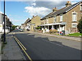
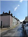
4
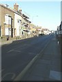
Looking north along Canterbury Road (A290)
Scaffolding had been erected on the frontage of number 34 up to roof level.
Image: © John Baker
Taken: 25 Dec 2014
0.02 miles
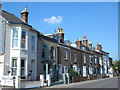
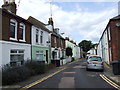
5
Essex Street, Whitstable
Behind the camera this continues as Swanfield Road.
The sky had cleared after an hour or so of heavy rain, with thunder and hailstones.
Image: © Stefan Czapski
Taken: 5 Aug 2017
0.03 miles
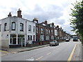
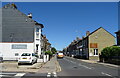
9
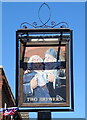
Sign for the Two Brewers, Whitstable
See Image] for context.
Image: © JThomas
Taken: 22 Jun 2022
0.04 miles
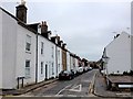
10
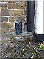
OS flush bracket - Whitstable, The Two Brewers pub
OS Flush Bracket S0674, mounted to the front wall of The Two Brewers public house on Canterbury Road; originally levelled in 1959 at 21' 8" above Ornance Datum Newlyn as part of the 3rd Geodetic Levelling of England and Wales.
Image: © Richard Law
Taken: 17 Aug 2014
0.05 miles