IMAGES TAKEN NEAR TO
Seasalter Lane, WHITSTABLE, CT5 4BT
Introduction
This page details the photographs taken nearby to Seasalter Lane, CT5 4BT by members of the Geograph project.
The Geograph project started in 2005 with the aim of publishing, organising and preserving representative images for every square kilometre of Great Britain, Ireland and the Isle of Man.

There are currently over 7.5m images from over14,400 individuals and you can help contribute to the project by visiting https://www.geograph.org.uk
Image Map
Images are licensed for reuse under creativecommons.org/licenses/by-sa/2.0
Notes
- Clicking on the map will re-center to the selected point.
- The higher the marker number, the further away the image location is from the centre of the postcode.
Image Listing (27 Images Found)
Images are licensed for reuse under creativecommons.org/licenses/by-sa/2.0
Image
Details
Distance
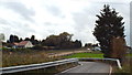
1
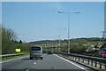
Seasalter Lane, near Whitstable
The concrete viaduct visible behind the electricity pylon carries the A299 road.
Image: © Malc McDonald
Taken: 26 Oct 2013
0.02 miles

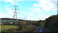
7
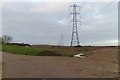
Electricity Pylons, Seasalter Levels
A similar view to this Geograph from 5 years ago: Image
Image: © Mark Anderson
Taken: 2 Jan 2019
0.08 miles
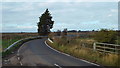
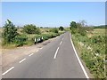
8
Sharp bend on Seasalter Lane
Seasalter Lane makes a tight loop to the west after running virtually due south from Image At this point it crosses a culverted drain and, unusually, a vehicle seems to have left the road on the inside of the bend, taking much of the old concrete post and steel pipe 'crash barrier' with it.
Image: © Penny Mayes
Taken: 15 Feb 2007
0.09 miles
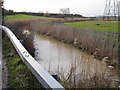
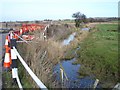
9

View of Seasalter and Seasalter Levels
Seen from a footpath near Seasalter Lane, leading past Mount Pleasant on its way to Highstreet Road, near Waterham.
Image: © David Anstiss
Taken: 26 Oct 2009
0.10 miles