IMAGES TAKEN NEAR TO
Corylus Drive, WHITSTABLE, CT5 4BF
Introduction
This page details the photographs taken nearby to Corylus Drive, CT5 4BF by members of the Geograph project.
The Geograph project started in 2005 with the aim of publishing, organising and preserving representative images for every square kilometre of Great Britain, Ireland and the Isle of Man.

There are currently over 7.5m images from over14,400 individuals and you can help contribute to the project by visiting https://www.geograph.org.uk
Image Map
Images are licensed for reuse under creativecommons.org/licenses/by-sa/2.0
Notes
- Clicking on the map will re-center to the selected point.
- The higher the marker number, the further away the image location is from the centre of the postcode.
Image Listing (74 Images Found)
Images are licensed for reuse under creativecommons.org/licenses/by-sa/2.0
Image
Details
Distance
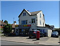
4
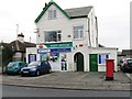
Whitstable General Store and Post Office
Image: © Alex McGregor
Taken: 10 Feb 2015
0.08 miles
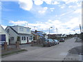
6
Seasalter Post Office
The Post Office on Joy Lane.
Image: © Gordon Griffiths
Taken: 23 Jul 2009
0.09 miles
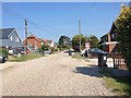
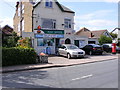
8
Seasalter Store and Post Office
On Joy Lane.
See Image] for postbox.
Image: © JThomas
Taken: 22 Jun 2022
0.10 miles
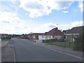
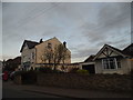
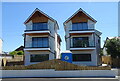
10
Houses on Joy Lane, Whitstable
The houses on the left were completed in 2014, there are a few more to the left out of shot.
Image: © David Howard
Taken: 19 Mar 2017
0.10 miles