IMAGES TAKEN NEAR TO
Allan Road, WHITSTABLE, CT5 4AH
Introduction
This page details the photographs taken nearby to Allan Road, CT5 4AH by members of the Geograph project.
The Geograph project started in 2005 with the aim of publishing, organising and preserving representative images for every square kilometre of Great Britain, Ireland and the Isle of Man.

There are currently over 7.5m images from over14,400 individuals and you can help contribute to the project by visiting https://www.geograph.org.uk
Image Map
Images are licensed for reuse under creativecommons.org/licenses/by-sa/2.0
Notes
- Clicking on the map will re-center to the selected point.
- The higher the marker number, the further away the image location is from the centre of the postcode.
Image Listing (81 Images Found)
Images are licensed for reuse under creativecommons.org/licenses/by-sa/2.0
Image
Details
Distance
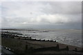
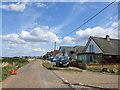
2
Allan Road View
The sea front at Seasalter.
Image: © Gordon Griffiths
Taken: 23 Jul 2009
0.06 miles
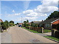
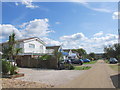
5
The road from Seasalter to Whitstable
The Blue Anchor hotel is on the left and the entrance to the Blue Anchor Caravan Park on the right
Image: © Elliott Simpson
Taken: 28 Apr 2009
0.08 miles
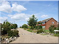
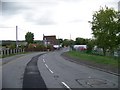
7
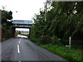
Railway Bridge, Seasalter
Driving towards Whitstable, Faversham Road, Seasalter.
Image: © Phillip Perry
Taken: 23 Sep 2008
0.09 miles
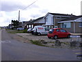
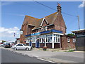
8
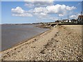
Seasalter Beach
Looking east with Whitstable beyond and Herne Bay on the left.
Image: © Penny Mayes
Taken: 1 Apr 2006
0.09 miles