IMAGES TAKEN NEAR TO
Boorman Way, WHITSTABLE, CT5 3SE
Introduction
This page details the photographs taken nearby to Boorman Way, CT5 3SE by members of the Geograph project.
The Geograph project started in 2005 with the aim of publishing, organising and preserving representative images for every square kilometre of Great Britain, Ireland and the Isle of Man.

There are currently over 7.5m images from over14,400 individuals and you can help contribute to the project by visiting https://www.geograph.org.uk
Image Map
Images are licensed for reuse under creativecommons.org/licenses/by-sa/2.0
Notes
- Clicking on the map will re-center to the selected point.
- The higher the marker number, the further away the image location is from the centre of the postcode.
Image Listing (17 Images Found)
Images are licensed for reuse under creativecommons.org/licenses/by-sa/2.0
Image
Details
Distance
1
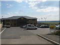
Gazette House (KM Building), Whitstable
This new offices is in Estuary View Business Park off the A2990 Thanet Way.
The estate car park is also being used as a trial Park and Ride scheme (mini-bus seen on the left). This has been started on weekends to easy congestion in Whitstable. Especially busy this weekend due to the popular Oyster Festival.
Image: © David Anstiss
Taken: 25 Jul 2009
0.01 miles
2
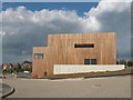
New Offices in Estuary View Business Park, Whitstable
This new timber clad office is in the new business park on the A2290 Thanet Way. Park, roads and office not yet finished.
Image: © David Anstiss
Taken: 25 Jul 2009
0.06 miles
3
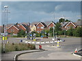
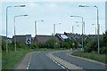
Roundabout on A2990 Thanet Way
This roundabout is on the link road from the A299 dual carriage way leading from the M2 Motorway to the Thanet Way towns. It is seen from Estuary View Business Park access road.
Image: © David Anstiss
Taken: 25 Jul 2009
0.07 miles
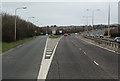
8
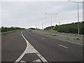
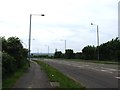
The A299 Thanet Way dual carriageway
This busy road, leads from the M2, past Whitstable. It now heads towards Herne Bay and then onto Ramsgate / Margate. Seen from an emergency link from the A2990 Thanet Way.
Image: © David Anstiss
Taken: 1 Aug 2009
0.15 miles
9
A299 near Whitstable
The A2990 peels away from the A299 to serve the town of Whitstable and to connect with the A290.
Image: © Martin Addison
Taken: 21 Mar 2015
0.16 miles
10
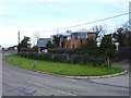
House on Wraik Hill
Plainly designed to make the most of its wonderful view up the Swale and across the Isle of Sheppey.
Image: © Penny Mayes
Taken: 15 Feb 2007
0.17 miles