IMAGES TAKEN NEAR TO
Grasmere Road, WHITSTABLE, CT5 3LY
Introduction
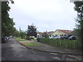
This page details the photographs taken nearby to Grasmere Road, CT5 3LY by members of the Geograph project.
The Geograph project started in 2005 with the aim of publishing, organising and preserving representative images for every square kilometre of Great Britain, Ireland and the Isle of Man.

There are currently over 7.5m images from over14,400 individuals and you can help contribute to the project by visiting https://www.geograph.org.uk
Image Map
Images are licensed for reuse under creativecommons.org/licenses/by-sa/2.0
Notes
- Clicking on the map will re-center to the selected point.
- The higher the marker number, the further away the image location is from the centre of the postcode.
Image Listing (37 Images Found)
Images are licensed for reuse under creativecommons.org/licenses/by-sa/2.0
Image
Details
Distance
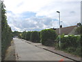
2
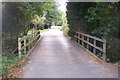
Bridge on Grasmere Road, Chestfield
This bridge over a river from Longtye Wood, also signifies a change from Road to Restricted Byway. The byway leads to South Tankerton.
Image: © David Anstiss
Taken: 30 Sep 2009
0.07 miles

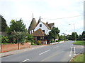
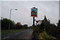
6
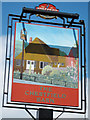
Chestfield Barn sign
Sign for Image, A Shepherd Neame pub on Chestfield Road.
Image: © Oast House Archive
Taken: 31 May 2011
0.16 miles