IMAGES TAKEN NEAR TO
Thanet Way, WHITSTABLE, CT5 3FS
Introduction
This page details the photographs taken nearby to Thanet Way, CT5 3FS by members of the Geograph project.
The Geograph project started in 2005 with the aim of publishing, organising and preserving representative images for every square kilometre of Great Britain, Ireland and the Isle of Man.

There are currently over 7.5m images from over14,400 individuals and you can help contribute to the project by visiting https://www.geograph.org.uk
Image Map
Images are licensed for reuse under creativecommons.org/licenses/by-sa/2.0
Notes
- Clicking on the map will re-center to the selected point.
- The higher the marker number, the further away the image location is from the centre of the postcode.
Image Listing (32 Images Found)
Images are licensed for reuse under creativecommons.org/licenses/by-sa/2.0
Image
Details
Distance
1
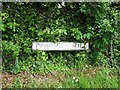
Vintage street nameplate, Clapham Hill, near Whitstable
Image: © Chris Whippet
Taken: 5 May 2014
0.06 miles
3
Borstal Hill at the junction of Thanet Way
Image: © David Howard
Taken: 19 Mar 2017
0.09 miles
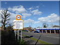
5
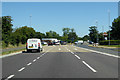
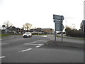
A2990 Thanet Way, Whitstable
Ahead is a roundabout - A290 right to Canterbury and also for access to the A299, London bound, left into the town centre.
Image: © Robin Webster
Taken: 2 Jul 2018
0.09 miles
6
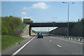
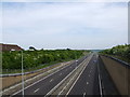
Bridge Over A299, Thanet Way
Carrying the A290 to Whitstable.
Image: © Oast House Archive
Taken: 23 Apr 2010
0.10 miles
9
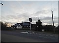
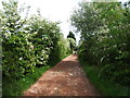
Welcome to Whitstable
This is Borstal Hill on the approach to Whitstable from the north.
Image: © Marathon
Taken: 12 Mar 2020
0.12 miles
10
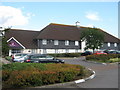
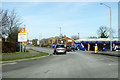
Whitstable Premier Inn
This motel is behind the Long Reach Beefeater pub/restaurant on the A2990 Thanet Way
Image: © David Anstiss
Taken: 25 Jul 2009
0.12 miles