IMAGES TAKEN NEAR TO
Radfall Ride, WHITSTABLE, CT5 3EW
Introduction
This page details the photographs taken nearby to Radfall Ride, CT5 3EW by members of the Geograph project.
The Geograph project started in 2005 with the aim of publishing, organising and preserving representative images for every square kilometre of Great Britain, Ireland and the Isle of Man.

There are currently over 7.5m images from over14,400 individuals and you can help contribute to the project by visiting https://www.geograph.org.uk
Image Map
Images are licensed for reuse under creativecommons.org/licenses/by-sa/2.0
Notes
- Clicking on the map will re-center to the selected point.
- The higher the marker number, the further away the image location is from the centre of the postcode.
Image Listing (21 Images Found)
Images are licensed for reuse under creativecommons.org/licenses/by-sa/2.0
Image
Details
Distance
1
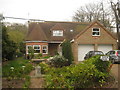
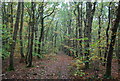
Birch Trees
House on Radfall Ride, has an extension inspired from an Oast House.
Image: © David Anstiss
Taken: 25 Apr 2010
0.00 miles
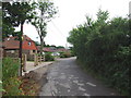
3
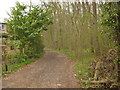
Radfall Ride
This track is classified as a bridleway leading from Woodside Wood towards Radfall Road. Along the track are many cottages and houses.
Image: © David Anstiss
Taken: 25 Apr 2010
0.09 miles
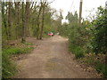
5
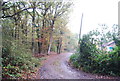
Bridleway to Radfall Road
This track leads from Radfall Ride (and row of houses/cottages) past Lypeatt Wood (on the right).
Image: © David Anstiss
Taken: 25 Apr 2010
0.14 miles