IMAGES TAKEN NEAR TO
Radfall Road, WHITSTABLE, CT5 3ER
Introduction
This page details the photographs taken nearby to Radfall Road, CT5 3ER by members of the Geograph project.
The Geograph project started in 2005 with the aim of publishing, organising and preserving representative images for every square kilometre of Great Britain, Ireland and the Isle of Man.

There are currently over 7.5m images from over14,400 individuals and you can help contribute to the project by visiting https://www.geograph.org.uk
Image Map
Images are licensed for reuse under creativecommons.org/licenses/by-sa/2.0
Notes
- Clicking on the map will re-center to the selected point.
- The higher the marker number, the further away the image location is from the centre of the postcode.
Image Listing (5 Images Found)
Images are licensed for reuse under creativecommons.org/licenses/by-sa/2.0
Image
Details
Distance
1
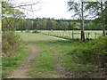
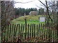
Paddocks at Mill Farm
A cleared area of Thornden Wood by Radfall Road.
Image: © Jonathan Billinger
Taken: 25 Apr 2007
0.10 miles
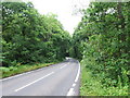
4
Radfall Road, heading south
Clowes Wood to the right, Thornden Wood to the left.
Image: © Robin Webster
Taken: 2 Jul 2018
0.23 miles
5
A covered reservoir near Gypsy Corner, Radfall Road
Image: © Nick Smith
Taken: 30 Mar 2008
0.25 miles