IMAGES TAKEN NEAR TO
Honey Hill, WHITSTABLE, CT5 3BP
Introduction
This page details the photographs taken nearby to Honey Hill, CT5 3BP by members of the Geograph project.
The Geograph project started in 2005 with the aim of publishing, organising and preserving representative images for every square kilometre of Great Britain, Ireland and the Isle of Man.

There are currently over 7.5m images from over14,400 individuals and you can help contribute to the project by visiting https://www.geograph.org.uk
Image Map
Images are licensed for reuse under creativecommons.org/licenses/by-sa/2.0
Notes
- Clicking on the map will re-center to the selected point.
- The higher the marker number, the further away the image location is from the centre of the postcode.
Image Listing (37 Images Found)
Images are licensed for reuse under creativecommons.org/licenses/by-sa/2.0
Image
Details
Distance
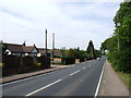
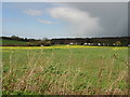
3
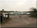
A290 past Meadow Grange Nursery
Heading towards Whitstable.
Image: © Robin Webster
Taken: 8 Feb 2018
0.06 miles
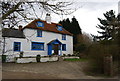
4
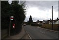
Bus Stop outside Red Lion House, A290
The bus to Canterbury stops here.
Image: © N Chadwick
Taken: 14 Mar 2009
0.07 miles
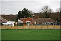
5
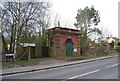
Mid Kent Water Building, A290 near Red Lion House
Image: © N Chadwick
Taken: 14 Mar 2009
0.07 miles
8
An interesting roadside advert near Red lion House, A290
Image: © N Chadwick
Taken: 14 Mar 2009
0.08 miles
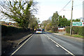
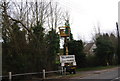
9

Looking in the direction of Whitstable along the A290
Image: © Nick Smith
Taken: 8 Apr 2008
0.08 miles
10
Meadow Green Nursery
On A290 Honey Hill.
Image: © David Anstiss
Taken: 25 Apr 2010
0.09 miles