IMAGES TAKEN NEAR TO
Pean Court Road, WHITSTABLE, CT5 3BA
Introduction
This page details the photographs taken nearby to Pean Court Road, CT5 3BA by members of the Geograph project.
The Geograph project started in 2005 with the aim of publishing, organising and preserving representative images for every square kilometre of Great Britain, Ireland and the Isle of Man.

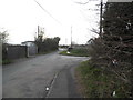
There are currently over 7.5m images from over14,400 individuals and you can help contribute to the project by visiting https://www.geograph.org.uk
Image Map
Images are licensed for reuse under creativecommons.org/licenses/by-sa/2.0
Notes
- Clicking on the map will re-center to the selected point.
- The higher the marker number, the further away the image location is from the centre of the postcode.
Image Listing (14 Images Found)
Images are licensed for reuse under creativecommons.org/licenses/by-sa/2.0
Image
Details
Distance
2
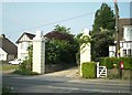
Old gateposts at the entrance of Court Lees Farm
Image: © Thomas Grant
Taken: 4 May 2007
0.07 miles
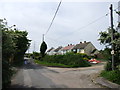
5
Clapham Hill at the junction of Pye Alley Lane
Image: © David Howard
Taken: 19 Mar 2017
0.18 miles
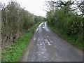
6
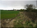
View along field boundary with Pye Alley Lane
Image: © Nick Smith
Taken: 8 Apr 2008
0.19 miles
7
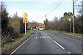
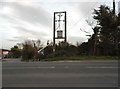
A290 towards Whitstable
The inconveniently situated bus stop is called Pye Alley, the left turn ahead is Pye Alley Lane.
Image: © Robin Webster
Taken: 8 Feb 2018
0.19 miles
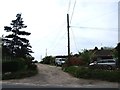
8
Electricity transformer on Pean Hill, Whitstable
Image: © David Howard
Taken: 19 Mar 2017
0.20 miles
9
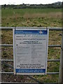
Notice on gate on Pye Alley Lane
There were several similar notices on farm roads and field gates in the area, giving notice of the refurbishment of the 400KV line.
Image: © Nick Smith
Taken: 8 Apr 2008
0.20 miles