IMAGES TAKEN NEAR TO
Pean Hill, WHITSTABLE, CT5 3AZ
Introduction
This page details the photographs taken nearby to Pean Hill, CT5 3AZ by members of the Geograph project.
The Geograph project started in 2005 with the aim of publishing, organising and preserving representative images for every square kilometre of Great Britain, Ireland and the Isle of Man.

There are currently over 7.5m images from over14,400 individuals and you can help contribute to the project by visiting https://www.geograph.org.uk
Image Map
Images are licensed for reuse under creativecommons.org/licenses/by-sa/2.0
Notes
- Clicking on the map will re-center to the selected point.
- The higher the marker number, the further away the image location is from the centre of the postcode.
Image Listing (19 Images Found)
Images are licensed for reuse under creativecommons.org/licenses/by-sa/2.0
Image
Details
Distance
1
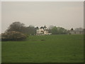
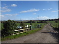
Court Leas Manor
As seen from a footpath from Pean Hill to Bogshole Lane. On the right is Court Lees Farm.
Image: © David Anstiss
Taken: 25 Apr 2010
0.04 miles
2
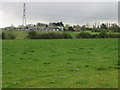
Court Lees Farm and Manor from Bogshole Lane
Image: © Nick Smith
Taken: 8 Apr 2008
0.05 miles
4
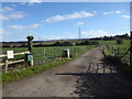
The approach to Court Lees Farm
This is the view from Bogshole Lane.
Image: © Marathon
Taken: 12 Mar 2020
0.17 miles
5
The entrance to Court Lees Farm
This is the view from Bogshole Lane.
Image: © Marathon
Taken: 12 Mar 2020
0.17 miles
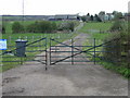
6
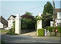
Old gateposts at the entrance of Court Lees Farm
Image: © Thomas Grant
Taken: 4 May 2007
0.17 miles
7
Court Lees Farm
This is the view from Bogshole Lane.
Image: © Marathon
Taken: 12 Mar 2020
0.18 miles
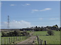
9
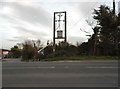
Electricity transformer on Pean Hill, Whitstable
Image: © David Howard
Taken: 19 Mar 2017
0.22 miles
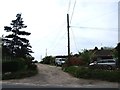
10

Bogshole Lane
This is the view from the entrance to Court Lees Farm
Image: © Marathon
Taken: 12 Mar 2020
0.23 miles