IMAGES TAKEN NEAR TO
Childgate Road, WHITSTABLE, CT5 3AQ
Introduction
This page details the photographs taken nearby to Childgate Road, CT5 3AQ by members of the Geograph project.
The Geograph project started in 2005 with the aim of publishing, organising and preserving representative images for every square kilometre of Great Britain, Ireland and the Isle of Man.

There are currently over 7.5m images from over14,400 individuals and you can help contribute to the project by visiting https://www.geograph.org.uk
Image Map
Images are licensed for reuse under creativecommons.org/licenses/by-sa/2.0
Notes
- Clicking on the map will re-center to the selected point.
- The higher the marker number, the further away the image location is from the centre of the postcode.
Image Listing (21 Images Found)
Images are licensed for reuse under creativecommons.org/licenses/by-sa/2.0
Image
Details
Distance
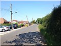
1
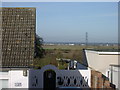
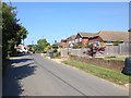
Yorkletts, looking across to Seasalter
This is the view seen by the residents of the bungalows that line the lane at Yorkletts.
Image: © pam fray
Taken: 12 Nov 2007
0.05 miles
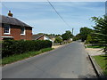
2
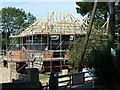
House under construction
Garden grab on Dargate Road.
Image: © Oast House Archive
Taken: 1 Sep 2010
0.06 miles
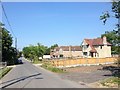
8
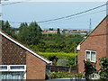
View to Seasalter
Looking between bungalows on Dargate Road.
Image: © Oast House Archive
Taken: 1 Sep 2010
0.11 miles
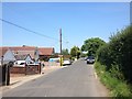
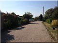
10
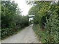
Ford Walk, Yorkletts
This unmade track leads up to Coombe Walk - see https://www.geograph.org.uk/photo/6019106
Image: © Marathon
Taken: 20 Sep 2022
0.14 miles