IMAGES TAKEN NEAR TO
Goodwin Avenue, WHITSTABLE, CT5 2QX
Introduction
This page details the photographs taken nearby to Goodwin Avenue, CT5 2QX by members of the Geograph project.
The Geograph project started in 2005 with the aim of publishing, organising and preserving representative images for every square kilometre of Great Britain, Ireland and the Isle of Man.

There are currently over 7.5m images from over14,400 individuals and you can help contribute to the project by visiting https://www.geograph.org.uk
Image Map
Images are licensed for reuse under creativecommons.org/licenses/by-sa/2.0
Notes
- Clicking on the map will re-center to the selected point.
- The higher the marker number, the further away the image location is from the centre of the postcode.
Image Listing (50 Images Found)
Images are licensed for reuse under creativecommons.org/licenses/by-sa/2.0
Image
Details
Distance
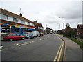
1
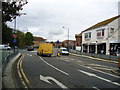
Looking NE along St John's Road, Swalecliffe
Image: © Nick Smith
Taken: 20 May 2008
0.05 miles
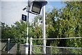
2
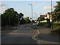
Chestfield, St John's Road, Pedestrian Crossing
Pedestrian crossing near Chestfield and Swalecliffe Station.
Image: © David Dixon
Taken: 16 May 2013
0.06 miles
3
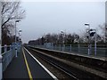
Chestfield & Swalecliffe station
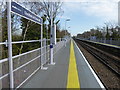
The route between Faversham and Whitstable was opened by the Margate Railway on 1st August 1860, and was extended to Herne Bay on 13th July 1861. What is now Chestfield & Swalecliffe station was originally opened as "Swalecliffe Halt" on 6 July 1930 by the Southern Railway. It was later renamed "Chestfield & Swalecliffe Halt", then shortened to "Chestfield" in 1987 and reverted to "Chestfield & Swalecliffe" in 1989.
This is the view from the down platform. The next station in this direction is Herne Bay.
Image: © Marathon
Taken: 28 Mar 2017
0.06 miles
4

Chestfield & Swalecliffe station
The route between Faversham and Whitstable was opened by the Margate Railway on 1st August 1860, and was extended to Herne Bay on 13th July 1861. What is now Chestfield & Swalecliffe station was originally opened as "Swalecliffe Halt" on 6 July 1930 by the Southern Railway. It was later renamed "Chestfield & Swalecliffe Halt", then shortened to "Chestfield" in 1987 and reverted to "Chestfield & Swalecliffe" in 1989.
This is the view from the down platform. The next station in this direction is Herne Bay.
Image: © Marathon
Taken: 28 Mar 2017
0.06 miles
5
Chestfield and Swalecliffe railway station
Image: © Stacey Harris
Taken: 15 Oct 2010
0.07 miles
7
TV Monitor, Chestfield & Swale Cliffe Station
Image: © N Chadwick
Taken: 4 Jul 2009
0.08 miles
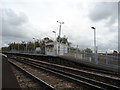
8

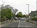
Pedestrian access to Chestfield and Swalecliffe railway station
The mini roundabout is at the junction of Herne Bay Road and St John's Road
Image: © Nick Smith
Taken: 20 May 2008
0.08 miles