IMAGES TAKEN NEAR TO
Princess Road, WHITSTABLE, CT5 2QW
Introduction
This page details the photographs taken nearby to Princess Road, CT5 2QW by members of the Geograph project.
The Geograph project started in 2005 with the aim of publishing, organising and preserving representative images for every square kilometre of Great Britain, Ireland and the Isle of Man.

There are currently over 7.5m images from over14,400 individuals and you can help contribute to the project by visiting https://www.geograph.org.uk
Image Map
Images are licensed for reuse under creativecommons.org/licenses/by-sa/2.0
Notes
- Clicking on the map will re-center to the selected point.
- The higher the marker number, the further away the image location is from the centre of the postcode.
Image Listing (72 Images Found)
Images are licensed for reuse under creativecommons.org/licenses/by-sa/2.0
Image
Details
Distance
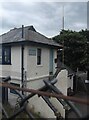
8
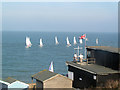
Tankerton Sailing Club
A race is being controlled by the two men on the flat roof.
Image: © Chris Reynolds
Taken: 13 Nov 2011
0.10 miles
9
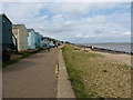
The Saxon Shore Way with beach huts
Beach huts along the frontage between Tankerton and Long Rock.
Image: © Richard Law
Taken: 17 Aug 2014
0.10 miles
10
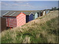
Back of beach huts at Swalecliffe
Colourful beach huts add interest to the walk between Herne Bay and Whitstable. These fine examples are at Swalecliffe, just east of Tankerton. The promontory known as Long Rock can be seen beyond.
Image: © Marathon
Taken: 17 Sep 2010
0.10 miles