IMAGES TAKEN NEAR TO
Bridgefield Road, WHITSTABLE, CT5 2PG

Introduction

This page details the photographs taken nearby to Bridgefield Road, CT5 2PG by members of the Geograph project.

The Geograph project started in 2005 with the aim of publishing, organising and preserving representative images for every square kilometre of Great Britain, Ireland and the Isle of Man.

There are currently over 7.5m images from over14,400 individuals and you can help contribute to the project by visiting https://www.geograph.org.uk

Image Map


Images are licensed for reuse under creativecommons.org/licenses/by-sa/2.0
Notes
  • Clicking on the map will re-center to the selected point.
  • The higher the marker number, the further away the image location is from the centre of the postcode.

Image Listing (70 Images Found)

Images are licensed for reuse under creativecommons.org/licenses/by-sa/2.0
  • ...
Image
Details
Distance
1
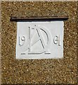
Date plaque (1904) and monogram (AD) on a house in St Swithin's Road, Tankerton
On the house seen in: http://www.geograph.org.uk/photo/5487825
Image: © Stefan Czapski Taken: 5 Aug 2017
0.12 miles
2
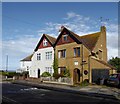
Houses with Arts & Crafts detailing, St Swithin's Road, Tankerton
At the seaward end of St Swithin's Road, close to Marine Crescent. Both houses have been altered; the pebble-dashed one retains some stained glass, the white one retains a hood-mould over the front door. Both retain a plaque with a monogram and the date - 1904: http://www.geograph.org.uk/photo/5487842 By chance, starlings were gathering on the aerials of both properties as I took the photo.
Image: © Stefan Czapski Taken: 5 Aug 2017
0.12 miles
3
Bennells Avenue, Tankerton
A small development of new houses on the corner of Bennells Avenue and Tankerton Road.
Image: © pam fray Taken: 6 Nov 2018
0.13 miles
4
Marine Crescent
Image: © David Dixon Taken: 16 May 2013
0.14 miles
5
Cafe on the clifftop
The cafe is on the greensward of the clifftop on Marine Crescent, Tankerton. A bus stop and cycle rack are adjacent.
Image: © Stephen Craven Taken: 24 Jul 2010
0.15 miles
6
Bungalows on Herne Bay Road
Image: © JThomas Taken: 22 Jun 2022
0.15 miles
7
Beachfront Holiday Accommodation
Bright colours on the beach huts at Tankerton Bay catch the eye.
Image: © Colin Smith Taken: 21 Jul 2007
0.16 miles
8
Tankerton Bay Sailing Club
Viewed from the promenade on the way to Swalecliffe, towards the end of Tankerton Slopes.
Image: © pam fray Taken: 17 Jan 2009
0.16 miles
9
Sea View Cafe, Tankerton
Image: © Neil Theasby Taken: 23 Mar 2019
0.16 miles
10
Looking westwards towards the Tankerton Sailing Club
The boats are on Tankerton slopes and the promenade is part of the Saxon Shore Way.
Image: © pam fray Taken: 17 Jan 2009
0.16 miles
  • ...