IMAGES TAKEN NEAR TO
Plough Lane, WHITSTABLE, CT5 2NZ
Introduction
This page details the photographs taken nearby to Plough Lane, CT5 2NZ by members of the Geograph project.
The Geograph project started in 2005 with the aim of publishing, organising and preserving representative images for every square kilometre of Great Britain, Ireland and the Isle of Man.

There are currently over 7.5m images from over14,400 individuals and you can help contribute to the project by visiting https://www.geograph.org.uk
Image Map
Images are licensed for reuse under creativecommons.org/licenses/by-sa/2.0
Notes
- Clicking on the map will re-center to the selected point.
- The higher the marker number, the further away the image location is from the centre of the postcode.
Image Listing (59 Images Found)
Images are licensed for reuse under creativecommons.org/licenses/by-sa/2.0
Image
Details
Distance
2
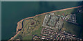
Seaview caravan park from the air
At Saxon Shore, Swalecliffe http://www.parkholidays.com/kent-caravan-holiday-park/seaview-whitstable .
Image: © Thomas Nugent
Taken: 14 Sep 2015
0.05 miles
8
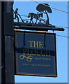
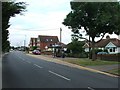
Sign for the Plough, Whitstable
See Image] for context.
Image: © JThomas
Taken: 22 Jun 2022
0.09 miles
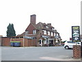
9
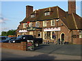
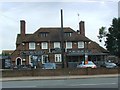
The Plough Inn, St John's Road, Swalecliffe
Image: © Nick Smith
Taken: 20 May 2008
0.09 miles