IMAGES TAKEN NEAR TO
Tassells Walk, WHITSTABLE, CT5 2NQ
Introduction
This page details the photographs taken nearby to Tassells Walk, CT5 2NQ by members of the Geograph project.
The Geograph project started in 2005 with the aim of publishing, organising and preserving representative images for every square kilometre of Great Britain, Ireland and the Isle of Man.

There are currently over 7.5m images from over14,400 individuals and you can help contribute to the project by visiting https://www.geograph.org.uk
Image Map
Images are licensed for reuse under creativecommons.org/licenses/by-sa/2.0
Notes
- Clicking on the map will re-center to the selected point.
- The higher the marker number, the further away the image location is from the centre of the postcode.
Image Listing (71 Images Found)
Images are licensed for reuse under creativecommons.org/licenses/by-sa/2.0
Image
Details
Distance

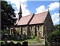
4
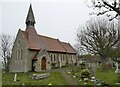
St. John the Baptist Church, Swalecliffe
Built in 1875, a Grade II listed building.
Image: © pam fray
Taken: 20 Apr 2021
0.10 miles
7
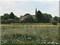
St John's church, from across the marsh
A view of St John the Baptist (an Anglican church in the Whitstable team ministry) from the coastal path. For a closer view see Image
Image: © Stephen Craven
Taken: 24 Jul 2010
0.11 miles
8
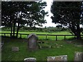
St John the Baptist, Swalecliffe, Kent - Churchyard
Image: © John Salmon
Taken: 19 Jun 2008
0.11 miles
10
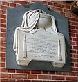
St John the Baptist, Swalecliffe, Kent - Wall monument
Image: © John Salmon
Taken: 19 Jun 2008
0.11 miles