IMAGES TAKEN NEAR TO
Manor Road, WHITSTABLE, CT5 2JT
Introduction
This page details the photographs taken nearby to Manor Road, CT5 2JT by members of the Geograph project.
The Geograph project started in 2005 with the aim of publishing, organising and preserving representative images for every square kilometre of Great Britain, Ireland and the Isle of Man.

There are currently over 7.5m images from over14,400 individuals and you can help contribute to the project by visiting https://www.geograph.org.uk
Image Map
Images are licensed for reuse under creativecommons.org/licenses/by-sa/2.0
Notes
- Clicking on the map will re-center to the selected point.
- The higher the marker number, the further away the image location is from the centre of the postcode.
Image Listing (133 Images Found)
Images are licensed for reuse under creativecommons.org/licenses/by-sa/2.0
Image
Details
Distance
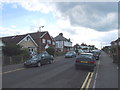
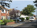
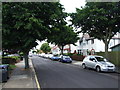
1
Manor Road
The west side, north of Northwood Road.
Image: © Mike Quinn
Taken: 21 Sep 2016
0.03 miles
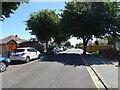
4
Graystone Road
The west side, north of Northwood Road.
Image: © Mike Quinn
Taken: 21 Sep 2016
0.06 miles
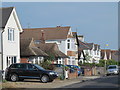
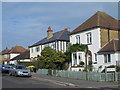
5
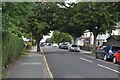
Graystone Road, Tankerton
Typical north Kent seaside suburban street, leading to the seafront.
Image: © David Martin
Taken: 20 Jul 2021
0.06 miles
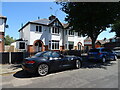
7
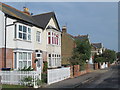
Wynn Road
The west side, north of Northwood Road.
Image: © Mike Quinn
Taken: 21 Sep 2016
0.06 miles
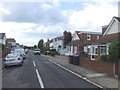
9
Northwood Road (3)
The north side, west of Manor Road.
Image: © Mike Quinn
Taken: 21 Sep 2016
0.07 miles