IMAGES TAKEN NEAR TO
St. Swithins Road, WHITSTABLE, CT5 2HX
Introduction
This page details the photographs taken nearby to St. Swithins Road, CT5 2HX by members of the Geograph project.
The Geograph project started in 2005 with the aim of publishing, organising and preserving representative images for every square kilometre of Great Britain, Ireland and the Isle of Man.

There are currently over 7.5m images from over14,400 individuals and you can help contribute to the project by visiting https://www.geograph.org.uk
Image Map
Images are licensed for reuse under creativecommons.org/licenses/by-sa/2.0
Notes
- Clicking on the map will re-center to the selected point.
- The higher the marker number, the further away the image location is from the centre of the postcode.
Image Listing (55 Images Found)
Images are licensed for reuse under creativecommons.org/licenses/by-sa/2.0
Image
Details
Distance
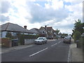
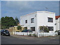
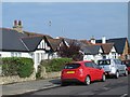
3

Bennells Avenue, Tankerton
A small development of new houses on the corner of Bennells Avenue and Tankerton Road.
Image: © pam fray
Taken: 6 Nov 2018
0.15 miles
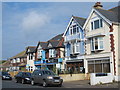
4
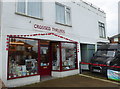
Crossed Threads, Tankerton
In Tankerton Road, near Ellis Road. The shop has displays of poppies outside and one of their windows devoted to Kent soldiers who died in World War I.
Image: © pam fray
Taken: 6 Nov 2018
0.15 miles
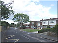
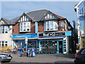
7
Pier Avenue
The west side, north of Northwood Road.
Image: © Mike Quinn
Taken: 21 Sep 2016
0.17 miles