IMAGES TAKEN NEAR TO
Bennells Avenue, WHITSTABLE, CT5 2HR
Introduction
This page details the photographs taken nearby to Bennells Avenue, CT5 2HR by members of the Geograph project.
The Geograph project started in 2005 with the aim of publishing, organising and preserving representative images for every square kilometre of Great Britain, Ireland and the Isle of Man.

There are currently over 7.5m images from over14,400 individuals and you can help contribute to the project by visiting https://www.geograph.org.uk
Image Map
Images are licensed for reuse under creativecommons.org/licenses/by-sa/2.0
Notes
- Clicking on the map will re-center to the selected point.
- The higher the marker number, the further away the image location is from the centre of the postcode.
Image Listing (118 Images Found)
Images are licensed for reuse under creativecommons.org/licenses/by-sa/2.0
Image
Details
Distance
1
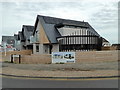
Bennells Avenue, Tankerton
A small development of new houses on the corner of Bennells Avenue and Tankerton Road.
Image: © pam fray
Taken: 6 Nov 2018
0.01 miles
2
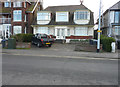
80, Marine Parade
Planning permission has been granted by Canterbury City Council under application number CA//15/02434 for the “demolition of existing dwelling and garages and construction of replacement dwelling and studio/annexe accommodation”. The garages are situated behind the house, at the bottom of the garden, and can be accessed along a one car’s width track that runs between Tankerton Road and Bennells Avenue.
Image: © John Baker
Taken: 6 Mar 2016
0.04 miles
4
Sea view, Tankerton
A good prospect over the beach east of Whitstable.
Image: © Jim Barton
Taken: 9 Aug 2023
0.07 miles
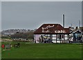
5
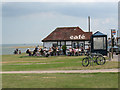
Cafe on the clifftop
The cafe is on the greensward of the clifftop on Marine Crescent, Tankerton. A bus stop and cycle rack are adjacent.
Image: © Stephen Craven
Taken: 24 Jul 2010
0.07 miles
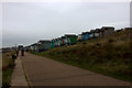
6
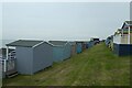
Rows of beach huts
Looking along lines of beach huts beside Tankerton Beach.
Image: © DS Pugh
Taken: 14 Sep 2021
0.08 miles
7
Above Tankerton Beach
Looking down towards Tankerton Beach from a little cafe.
Image: © DS Pugh
Taken: 14 Sep 2021
0.08 miles
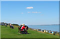
10
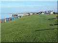
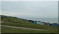
Tankerton Slopes
Above the two rows of Beach Huts and beside Marine Parade. This long patch of sloping grassland is favourite place to go with a picnic, children and kites and dogwalkers. In background, Sailing Club beside huts, toilet block (white building) and Cafe, also a fish and chip restaurant.
Image: © David Anstiss
Taken: 14 Feb 2009
0.09 miles