IMAGES TAKEN NEAR TO
Quinneys Place, WHITSTABLE, CT5 2GT
Introduction
This page details the photographs taken nearby to Quinneys Place, CT5 2GT by members of the Geograph project.
The Geograph project started in 2005 with the aim of publishing, organising and preserving representative images for every square kilometre of Great Britain, Ireland and the Isle of Man.

There are currently over 7.5m images from over14,400 individuals and you can help contribute to the project by visiting https://www.geograph.org.uk
Image Map
Images are licensed for reuse under creativecommons.org/licenses/by-sa/2.0
Notes
- Clicking on the map will re-center to the selected point.
- The higher the marker number, the further away the image location is from the centre of the postcode.
Image Listing (52 Images Found)
Images are licensed for reuse under creativecommons.org/licenses/by-sa/2.0
Image
Details
Distance
1
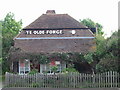
Ye Olde Forge
This 18th Century cottage on the Herne Bay Road is, as its name suggests, an old forge.
Image: © Nick Smith
Taken: 20 May 2008
0.02 miles
2
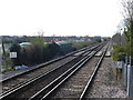
View up the line from Chestfield & Swalecliffe station
The route between Faversham and Whitstable was opened by the Margate Railway on 1st August 1860, and was extended to Herne Bay on 13th July 1861. What is now Chestfield & Swalecliffe station was originally opened as "Swalecliffe Halt" on 6 July 1930 by the Southern Railway. It was later renamed "Chestfield & Swalecliffe Halt", then shortened to "Chestfield" in 1987 and reverted to "Chestfield & Swalecliffe" in 1989.
This is the view from the down platform. The next station in this direction is Whitstable. The bridge just ahead is over the B2205.
Image: © Marathon
Taken: 28 Mar 2017
0.03 miles
3
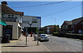
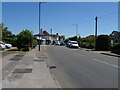
Herne Bay Road, Whitstable
Showing position of Postbox No. CT5 152.
See Image] for context.
Image: © JThomas
Taken: 22 Jun 2022
0.04 miles
4
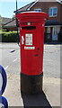
Elizabeth II postbox on Herne Bay Road, Whitstable
Postbox No. CT5 152.
Outside the Post Office.
See Image] for context
Image: © JThomas
Taken: 22 Jun 2022
0.04 miles
5
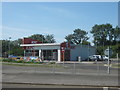
Chestfield KFC Restaurant
On the A2990, the site of a former garage which had been empty for many years, then was demolished and this new fastfood outlet joins a nearby McDonald's and car wash.
Image: © David Anstiss
Taken: 30 Jul 2011
0.04 miles
6
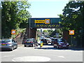
Railway bridge over Herne Bay Road (B2205)
Near Chestfield and Swalecliffe Railway Station.
Image: © JThomas
Taken: 22 Jun 2022
0.04 miles
8
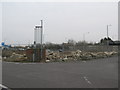
Rubble before the rising of KFC in Chestfield
Close to the existing McDonald's on the first roundabout on the A2990, this former garage has been empty for many years since it closed. Now construction of a new KFC will begin to take place soon.
Image: © David Anstiss
Taken: 18 Mar 2010
0.05 miles
9

Railway bridge over the Herne Bay Road at Swalecliffe
Image: © Nick Smith
Taken: 20 May 2008
0.05 miles
10
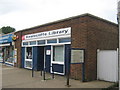
Swalecliffe Library
On Herne Bay Road, in a small parade of shops, near the Chestfield and Swalecliffe Railway Station. Sign outside gives a history of the area and map of local sights to see.
Image: © David Anstiss
Taken: 1 Aug 2009
0.05 miles