IMAGES TAKEN NEAR TO
Fitzroy Road, WHITSTABLE, CT5 2FA
Introduction
This page details the photographs taken nearby to Fitzroy Road, CT5 2FA by members of the Geograph project.
The Geograph project started in 2005 with the aim of publishing, organising and preserving representative images for every square kilometre of Great Britain, Ireland and the Isle of Man.

There are currently over 7.5m images from over14,400 individuals and you can help contribute to the project by visiting https://www.geograph.org.uk
Image Map
Images are licensed for reuse under creativecommons.org/licenses/by-sa/2.0
Notes
- Clicking on the map will re-center to the selected point.
- The higher the marker number, the further away the image location is from the centre of the postcode.
Image Listing (163 Images Found)
Images are licensed for reuse under creativecommons.org/licenses/by-sa/2.0
Image
Details
Distance
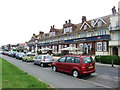
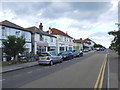
1
Shops on Tankerton Road
A parade of small shops in the residential area of Tankerton.
Image: © Richard Law
Taken: 17 Aug 2014
0.01 miles
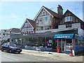
4
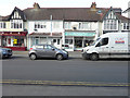
113, Tankerton Road
Number 113 is to the left of the shop called The Painted Pearl.
Image: © John Baker
Taken: 6 Mar 2016
0.03 miles
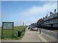
5
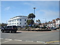
Roundabout, Tankerton Road, Tankerton
Image: © Stacey Harris
Taken: 10 Apr 2010
0.04 miles
6
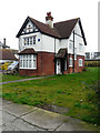
8, St Anne?s Road
The house is being demolished. This was Image from the WNW.
Image: © John Baker
Taken: 26 Jan 2020
0.05 miles
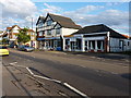
7
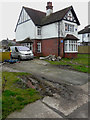
8, St Anne?s Road
The house is being demolished. This was Image from the southwest.
Image: © John Baker
Taken: 26 Jan 2020
0.05 miles