IMAGES TAKEN NEAR TO
Northwood Road, WHITSTABLE, CT5 2ET
Introduction
This page details the photographs taken nearby to Northwood Road, CT5 2ET by members of the Geograph project.
The Geograph project started in 2005 with the aim of publishing, organising and preserving representative images for every square kilometre of Great Britain, Ireland and the Isle of Man.

There are currently over 7.5m images from over14,400 individuals and you can help contribute to the project by visiting https://www.geograph.org.uk
Image Map
Images are licensed for reuse under creativecommons.org/licenses/by-sa/2.0
Notes
- Clicking on the map will re-center to the selected point.
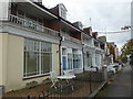
- The higher the marker number, the further away the image location is from the centre of the postcode.
Image Listing (309 Images Found)
Images are licensed for reuse under creativecommons.org/licenses/by-sa/2.0
Image
Details
Distance
1
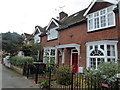
Northwood Road, Whitstable
A row of terraced houses at the northern end of the road, near the harbour.
Image: © pam fray
Taken: 6 Nov 2018
0.03 miles
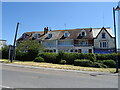
3
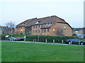
The Oysters, Whitstable
Flats, with some, if not all, sheltered housing.
Image: © Robin Webster
Taken: 9 Feb 2014
0.06 miles
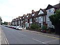
4
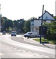
Mr Chips Fish Bar, Whitstable
On Tower Parade. Currently, very busy, due to the last days of the Oyster Festival Week in Whitstable, with main events going on in the nearby harbour.
Image: © David Anstiss
Taken: 25 Jul 2009
0.06 miles
5
Looking northwest along The Crab and Winkle Line
This part of The Crab and Winkle Way is accessed from The Sidings, a cul-de-sac off Station Road. The Crab and Winkle was the nickname for The Canterbury to Whitstable Railway which was opened on 3 May 1830 with stations at Canterbury West and Whitstable Harbour only. Three further stations were opened during the 20th century at Blean and Tyler Hill Halt on 13 June 1908, South Street Halt on 1 July 1911 and Tankerton Halt on 1 July 1914. The railway was closed to passengers on 31 December 1930 and to all traffic on 1 December 1952. However, the following year it was reopened from 6-28 February to carry essential services from Canterbury to Whitstable, as a result of the severe coastal flooding that occurred along the east coast of the UK early in 1953.
Image: © John Baker
Taken: 23 Jun 2013
0.06 miles
9
The Sidings
A cul-de-sac off Station Road. Proceeding to the ends of the cul-de-sac, one finds one is either Image or Image
Image: © John Baker
Taken: 23 Jun 2013
0.07 miles
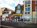
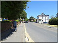
10
Tower Parade, Whitstable
This used to be a row of shops, but many of the establishments have become private residences.
Image: © pam fray
Taken: 6 Nov 2018
0.07 miles