IMAGES TAKEN NEAR TO
Seymour Avenue, WHITSTABLE, CT5 1SA
Introduction
This page details the photographs taken nearby to Seymour Avenue, CT5 1SA by members of the Geograph project.
The Geograph project started in 2005 with the aim of publishing, organising and preserving representative images for every square kilometre of Great Britain, Ireland and the Isle of Man.

There are currently over 7.5m images from over14,400 individuals and you can help contribute to the project by visiting https://www.geograph.org.uk
Image Map
Images are licensed for reuse under creativecommons.org/licenses/by-sa/2.0
Notes
- Clicking on the map will re-center to the selected point.
- The higher the marker number, the further away the image location is from the centre of the postcode.
Image Listing (130 Images Found)
Images are licensed for reuse under creativecommons.org/licenses/by-sa/2.0
Image
Details
Distance
1
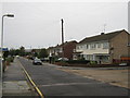
All Saints Close junction with Seymour Street
The Crab and Winkle Line (8 mile cycle path) heads right along All Saints Close towards the original line of the Crab and Winkle Railway. See Image
The cyclepath also heads left down Seymour Street towards Whitstable Railway Station on Old Bridge Road.
Image: © David Anstiss
Taken: 5 Oct 2010
0.04 miles
2
Crab and Winkle Way on All Saints Close
The 8 mile long cyclepath heads towards Image, the original route of the railway heading towards Canterbury. It comes from Seymour Street near Whitstable Railway Station.
Image: © David Anstiss
Taken: 5 Oct 2010
0.04 miles
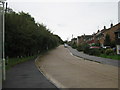
3
Crab and Winkle Way on Seymour Avenue
The 8 mile cyclepath leads from Whitstable Railway Station on Old Bridge Road, towards All Saints Close. The cyclepath also leads right towards Whitstable.
Via Image
Image: © David Anstiss
Taken: 5 Oct 2010
0.09 miles
5
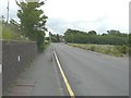
Old Bridge Road
To the left of the silver van, there is an abutment of a bridge, which would have carried The Canterbury to Whitstable Railway (nicknamed The Crab and Winkle) over the road and main railway line. It was opened on 3 May 1830 with stations at Canterbury West and Whitstable Harbour only. Three further stations were opened during the 20th century at Blean and Tyler Hill Halt on 13 June 1908, South Street Halt on 1 July 1911 and Tankerton Halt on 1 July 1914. The railway was closed to passengers on 31 December 1930 and to all traffic on 1 December 1952. However, the following year it was reopened from 6-28 February to carry essential services from Canterbury to Whitstable, as a result of the severe coastal flooding that occurred along the east coast of the UK early in 1953.
This was the Image in June 2013 before graffiti was painted on it and the fence disappeared under the growth of the plant called old man’s beard.
Image: © John Baker
Taken: 28 Sep 2019
0.10 miles
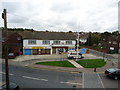
6
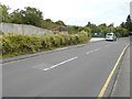
Old Bridge Road
The line of trees on the right hides an embankment that once carried The Canterbury to Whitstable Railway (nicknamed The Crab and Winkle). Here, it would have crossed the road on a bridge. It was opened on 3 May 1830 with stations at Canterbury West and Whitstable Harbour only. Three further stations were opened during the 20th century at Blean and Tyler Hill Halt on 13 June 1908, South Street Halt on 1 July 1911 and Tankerton Halt on 1 July 1914. The railway was closed to passengers on 31 December 1930 and to all traffic on 1 December 1952. However, the following year it was reopened from 6-28 February to carry essential services from Canterbury to Whitstable, as a result of the severe coastal flooding that occurred along the east coast of the UK early in 1953.
Image: © John Baker
Taken: 23 Jun 2013
0.10 miles
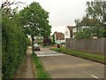
9
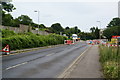
Roadworks on the Bridge Approach
Just by Whitstable railway station.
Image: © Bill Boaden
Taken: 27 Jun 2012
0.10 miles
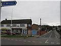
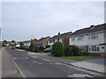
10
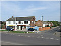
Local shops, Whitstable
Local shops on Old Bridge Road, Whitstable, opposite the railway station.
Image: © Malc McDonald
Taken: 1 May 2011
0.10 miles