IMAGES TAKEN NEAR TO
Summerfield Avenue, WHITSTABLE, CT5 1NR
Introduction
This page details the photographs taken nearby to Summerfield Avenue, CT5 1NR by members of the Geograph project.
The Geograph project started in 2005 with the aim of publishing, organising and preserving representative images for every square kilometre of Great Britain, Ireland and the Isle of Man.

There are currently over 7.5m images from over14,400 individuals and you can help contribute to the project by visiting https://www.geograph.org.uk
Image Map
Images are licensed for reuse under creativecommons.org/licenses/by-sa/2.0
Notes
- Clicking on the map will re-center to the selected point.
- The higher the marker number, the further away the image location is from the centre of the postcode.
Image Listing (74 Images Found)
Images are licensed for reuse under creativecommons.org/licenses/by-sa/2.0
Image
Details
Distance


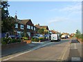

7
The Monument public house, Church Street Whitstable
Looking north towards the town centre. The Monument is an 18th century Grade II listed building.
Image: © pam fray
Taken: 23 Jul 2012
0.06 miles
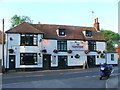
8
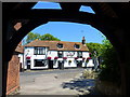
The Monument public house, Church Street Whitstable
Viewed through the lych gate. The Monument is an 18th century Grade II listed building.
Image: © pam fray
Taken: 23 Jul 2012
0.06 miles
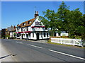
9
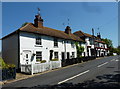
Cottages on Church Street, Whitstable
The Monument public house is at the end of the terrace.
Image: © pam fray
Taken: 23 Jul 2012
0.06 miles
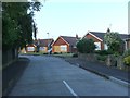
10
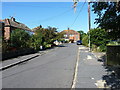
Friars Close, Tankerton
A quiet residential street of 1940s or 1950s houses, mainly semis.
Image: © Richard Law
Taken: 16 Aug 2014
0.07 miles