IMAGES TAKEN NEAR TO
Cromwell Road, WHITSTABLE, CT5 1NE
Introduction
This page details the photographs taken nearby to Cromwell Road, CT5 1NE by members of the Geograph project.
The Geograph project started in 2005 with the aim of publishing, organising and preserving representative images for every square kilometre of Great Britain, Ireland and the Isle of Man.

There are currently over 7.5m images from over14,400 individuals and you can help contribute to the project by visiting https://www.geograph.org.uk
Image Map
Images are licensed for reuse under creativecommons.org/licenses/by-sa/2.0
Notes
- Clicking on the map will re-center to the selected point.
- The higher the marker number, the further away the image location is from the centre of the postcode.
Image Listing (737 Images Found)
Images are licensed for reuse under creativecommons.org/licenses/by-sa/2.0
Image
Details
Distance
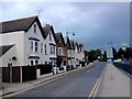
1
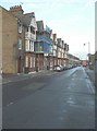
Houses along Cromwell Road
Number 3 is the house whose frontage is clad in scaffolding, possibly erected for maintenance to be carried out.
Image: © John Baker
Taken: 24 Nov 2013
0.01 miles

5
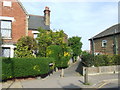
Cuckoo-Down-Lane, Whitstable
Cuckoo-Down-Lane, a public footpath in Whitstable.
Image: © Malc McDonald
Taken: 1 May 2011
0.05 miles

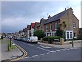
9

Harbourside Market - Whitstable
Seems to be a permanent feature here.
Image: © Colin Babb
Taken: 10 Jul 2010
0.06 miles
