IMAGES TAKEN NEAR TO
Wheatley Road, WHITSTABLE, CT5 1LS
Introduction
This page details the photographs taken nearby to Wheatley Road, CT5 1LS by members of the Geograph project.
The Geograph project started in 2005 with the aim of publishing, organising and preserving representative images for every square kilometre of Great Britain, Ireland and the Isle of Man.

There are currently over 7.5m images from over14,400 individuals and you can help contribute to the project by visiting https://www.geograph.org.uk
Image Map
Images are licensed for reuse under creativecommons.org/licenses/by-sa/2.0
Notes
- Clicking on the map will re-center to the selected point.
- The higher the marker number, the further away the image location is from the centre of the postcode.
Image Listing (196 Images Found)
Images are licensed for reuse under creativecommons.org/licenses/by-sa/2.0
Image
Details
Distance
3
W J Dempsey, Diamond Road/43 Reservoir Road
Planning permission has been granted by Canterbury City Council under application number CA//13/01729 for the “demolition of existing buildings and redevelopment of block of 22 flats with associated car parking and amenity space”. The notice board to the left of the building reads "FOR SALE. DEVELOPMENT SITE. Currently with planning consent for 20 apartments. For further information contact Neil Harrington - 01227 272302. Kent Estate Agencies". W J Dempsey, offered removal services to and from Ireland and all parts of the UK http://www.wjdempsey.co.uk/
These were the Image that were subsequently erected on the site.
Image: © John Baker
Taken: 23 Jun 2013
0.05 miles
4
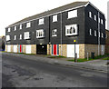
Block of flats, Diamond Road
They were erected on the site of Image
Image: © John Baker
Taken: 26 Jan 2020
0.06 miles
6
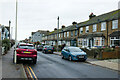
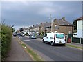
Houses on Westmeads Road
Viewed from the junction with Wheatley Road.
Image: © Mark Anderson
Taken: 19 Dec 2022
0.07 miles
7
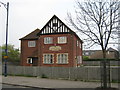
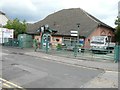
Masonic Temple
On junction of Cromwell Road (in front) and Diamond Road (unseen on right).
Image: © David Anstiss
Taken: 13 Apr 2009
0.07 miles
8
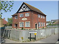
Masonic Temple, Whitstable
A Masonic Temple in Whitstable, Kent.
Image: © Malc McDonald
Taken: 1 May 2011
0.07 miles