IMAGES TAKEN NEAR TO
Cromwell Road, WHITSTABLE, CT5 1LA
Introduction
This page details the photographs taken nearby to Cromwell Road, CT5 1LA by members of the Geograph project.
The Geograph project started in 2005 with the aim of publishing, organising and preserving representative images for every square kilometre of Great Britain, Ireland and the Isle of Man.

There are currently over 7.5m images from over14,400 individuals and you can help contribute to the project by visiting https://www.geograph.org.uk
Image Map
Images are licensed for reuse under creativecommons.org/licenses/by-sa/2.0
Notes
- Clicking on the map will re-center to the selected point.
- The higher the marker number, the further away the image location is from the centre of the postcode.
Image Listing (811 Images Found)
Images are licensed for reuse under creativecommons.org/licenses/by-sa/2.0
Image
Details
Distance
3
Yarn bombing by Gorrell Tank Car Park
Image: © Oast House Archive
Taken: 24 Sep 2017
0.02 miles
4
Tower Parade, Tankerton
You can just make out a chimney of the works that spoil this part of the coast.
Image: © Phillip Perry
Taken: 17 Feb 2009
0.03 miles
5

Remembrance poppies, Whitstable
Knitted poppies on the railings of the Gorrell Tank car park in Harbour Street.
Image: © pam fray
Taken: 6 Nov 2018
0.03 miles
7
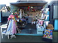
Harbour Market, Whitstable
One of the artisan vendors in a harbour setting.
Image: © pam fray
Taken: 30 Dec 2019
0.03 miles
8
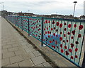
Remembrance poppies, Whitstable
Knitted poppies attached to net on the railings by the Gorrell Tank Car Park, Harbour Street.
Image: © pam fray
Taken: 6 Nov 2018
0.03 miles
9
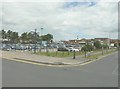
Gorrell Tank carpark
The carpark was once a backwater reservoir that was constructed in 1845, at a cost of £1200, to flush out mud in Whitstable harbour at low tide. At the entrance to the harbour, there was a sluice that was only opened during the incoming tide so as to fill the reservoir. At low tide, another sluice, closed during the incoming tide, was opened on the southeast side of the harbour so that the water stored in the reservoir could be channelled along a culvert and into the harbour to flush it.
Image: © John Baker
Taken: 23 Jun 2013
0.03 miles
10

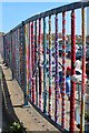
Yarn-bombing, Harbour Street, Whitstable
Whitstable has an active group of "yarn-bombers" - enthusiastic knitters and crocheters who seek to brighten up the town through their handiwork - and here a fence overlooking a car park has been thoroughly decorated.
(For the car park this borders, see Image).
Image: © Christopher Hilton
Taken: 23 Aug 2017
0.03 miles