IMAGES TAKEN NEAR TO
Pettman Mews, Island Wall, WHITSTABLE, CT5 1EU
Introduction
This page details the photographs taken nearby to Pettman Mews, Island Wall, CT5 1EU by members of the Geograph project.
The Geograph project started in 2005 with the aim of publishing, organising and preserving representative images for every square kilometre of Great Britain, Ireland and the Isle of Man.

There are currently over 7.5m images from over14,400 individuals and you can help contribute to the project by visiting https://www.geograph.org.uk
Image Map
Images are licensed for reuse under creativecommons.org/licenses/by-sa/2.0
Notes
- Clicking on the map will re-center to the selected point.
- The higher the marker number, the further away the image location is from the centre of the postcode.
Image Listing (538 Images Found)
Images are licensed for reuse under creativecommons.org/licenses/by-sa/2.0
Image
Details
Distance
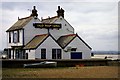
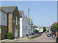
1
Island Wall, Whitstable, from the corner of Waterloo Road
Image: © pam fray
Taken: 22 Aug 2008
0.01 miles
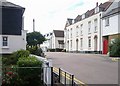
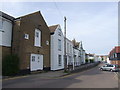
2
Island Wall, Whitstable
Houses on Island Wall in Whitstable.
Image: © Malc McDonald
Taken: 1 May 2011
0.01 miles
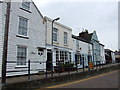
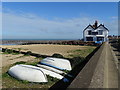
6
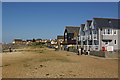
Island Wall
Houses off Island Wall, overlooking the beach. In the background are the Royal Native Oyster Stores (see Image).
Image: © Ian Capper
Taken: 8 Apr 2010
0.03 miles
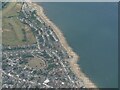
7
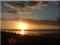
Whitstable beach
View from the beach at Whitstable during sunset, looking northwest. You can see the Isle of Sheppey in the distance.
Image: © Ben Charlton
Taken: 15 Jun 2004
0.03 miles