IMAGES TAKEN NEAR TO
West Cliff, WHITSTABLE, CT5 1DN
Introduction
This page details the photographs taken nearby to West Cliff, CT5 1DN by members of the Geograph project.
The Geograph project started in 2005 with the aim of publishing, organising and preserving representative images for every square kilometre of Great Britain, Ireland and the Isle of Man.

There are currently over 7.5m images from over14,400 individuals and you can help contribute to the project by visiting https://www.geograph.org.uk
Image Map
Images are licensed for reuse under creativecommons.org/licenses/by-sa/2.0
Notes
- Clicking on the map will re-center to the selected point.
- The higher the marker number, the further away the image location is from the centre of the postcode.
Image Listing (271 Images Found)
Images are licensed for reuse under creativecommons.org/licenses/by-sa/2.0
Image
Details
Distance
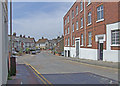
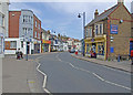
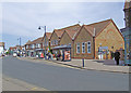
1
Oxford Street
Coach and Horses public house and Whitstable library in centre of picture.
Image: © Dennis Turner
Taken: 12 May 2009
0.01 miles
2
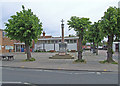
Public Library and War Memorial
Whitstable public library behind war memorial.
Image: © Dennis Turner
Taken: 12 May 2009
0.01 miles
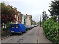
7
Oxford Street
Looking towards the direction of the harbour with Nelson Road to the left of picture.
Image: © Dennis Turner
Taken: 12 May 2009
0.05 miles
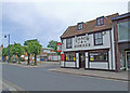
8
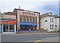
Oxford Street
Bingo hall former cinema in centre of picture.
Image: © Dennis Turner
Taken: 12 May 2009
0.05 miles
9
Oxford Street
With St Alphege CE Junior School in centre of picture.
Image: © Dennis Turner
Taken: 12 May 2009
0.05 miles