IMAGES TAKEN NEAR TO
Middle Wall, WHITSTABLE, CT5 1BJ
Introduction
This page details the photographs taken nearby to Middle Wall, CT5 1BJ by members of the Geograph project.
The Geograph project started in 2005 with the aim of publishing, organising and preserving representative images for every square kilometre of Great Britain, Ireland and the Isle of Man.

There are currently over 7.5m images from over14,400 individuals and you can help contribute to the project by visiting https://www.geograph.org.uk
Image Map
Images are licensed for reuse under creativecommons.org/licenses/by-sa/2.0
Notes
- Clicking on the map will re-center to the selected point.
- The higher the marker number, the further away the image location is from the centre of the postcode.
Image Listing (697 Images Found)
Images are licensed for reuse under creativecommons.org/licenses/by-sa/2.0
Image
Details
Distance
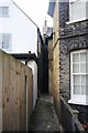
1
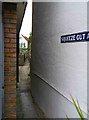
Squeeze Gut Alley, Whitstable, Kent
There is a good reason for this alley's name as if you have, as the saying goes, a "fuller figure", you might have difficulty getting through (so I didn't try). In days gone by the names of streets and lanes were much more blunt than today. It's good to see this name remains and that it hasn't been renamed Wisteria Lane or similar.
Image: © P L Chadwick
Taken: 7 Oct 2017
0.00 miles
2
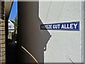
Squeeze Gut Alley, Whitstable
Just one of numerous tight alleys in Whitstable. This one is especially tight at the point where it meets Island Wall. Squeeze Gut Alley is also the name of an excellent local blues-rock band. See https://en-gb.facebook.com/squeezegutalleyband/
Image: © Neil Theasby
Taken: 24 Mar 2019
0.00 miles
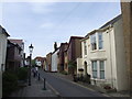
3
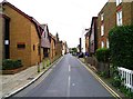
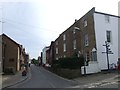
Middle Wall, Whitstable, Kent
A mainly residential back street in Whitstable's town centre.
Image: © P L Chadwick
Taken: 7 Oct 2017
0.01 miles
4
Squeeze Gut Alley, Whitstable
View shows increasingly narrow width of Squeeze Gut Alley. Image taken from western end, near junction with Island Wall road.
Image: © Clint Mann
Taken: 4 Mar 2011
0.02 miles
6
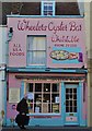
Oyster Bar on Whitstable's high street
Image: © Neil Theasby
Taken: 23 Mar 2019
0.02 miles
7
Royal Naval Reserve public house, Whitstable
Image: © Stacey Harris
Taken: 15 Oct 2010
0.02 miles
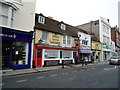
8
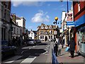
The Duke of Cumberland, Whitstable
This pub stands at the northern end of the High Street with Sea Street to the West and Harbour Street to the east.
Image: © Penny Mayes
Taken: 1 Apr 2006
0.02 miles
9
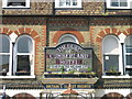
Hotel sign in stained glass, Whitstable, Kent
Image: © Jim Osley
Taken: 8 Jun 2006
0.02 miles