IMAGES TAKEN NEAR TO
Harbour Street, WHITSTABLE, CT5 1AD
Introduction
This page details the photographs taken nearby to Harbour Street, CT5 1AD by members of the Geograph project.
The Geograph project started in 2005 with the aim of publishing, organising and preserving representative images for every square kilometre of Great Britain, Ireland and the Isle of Man.

There are currently over 7.5m images from over14,400 individuals and you can help contribute to the project by visiting https://www.geograph.org.uk
Image Map
Images are licensed for reuse under creativecommons.org/licenses/by-sa/2.0
Notes
- Clicking on the map will re-center to the selected point.
- The higher the marker number, the further away the image location is from the centre of the postcode.
Image Listing (813 Images Found)
Images are licensed for reuse under creativecommons.org/licenses/by-sa/2.0
Image
Details
Distance
4
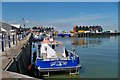
Workboats - Whitstable harbour
A pair of workboats that look as if they are used for the servicing of the wind farm that can be seen off of the coast near here.
Image: © Colin Babb
Taken: 10 Jul 2010
0.02 miles
5
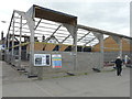
South Quay Shed, Whitstable Harbour, Harbour Street
Planning permission was granted by Canterbury City Council under application number CA//18/01438 for “change of use of warehouse to mixed use retail, restaurants and cafe, museums, exhibition space, educational use and assembly space, together with single-storey extensions to front and rear with terraces above, external alterations and siting of shipping containers”.
The notice affixed to the wall of the building and entitled South Quay Shed reads “the former old fishing and aggregate store, known as the South Quay Shed, is in the business of being transformed. The Whitstable Harbour Board is creating 850 sqm of mixed retail space including restaurants and cafes, a community museum, exhibition space and educational areas.
The plans include a large multipurpose internal courtyard surrounded by converted shipping containers in keeping with the harbour’s seafaring history on the ground and first floors. These will be complemented by a mezzanine deck.
Fully-glazed walls will help create a facility with unique views of the working harbour that can be used all year round.
The building will also take advantage of solar panels to generate its own power and high levels of insulation will help to keep the place warm in winter. This adds to the harbour board’s sustainability credentials”.
Image: © John Baker
Taken: 28 Sep 2019
0.02 miles
6
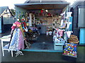
Harbour Market, Whitstable
One of the artisan vendors in a harbour setting.
Image: © pam fray
Taken: 30 Dec 2019
0.03 miles
7
Whitstable harbour: The Harbour Garden Cafe
Image: © Michael Garlick
Taken: 20 Dec 2016
0.03 miles
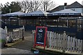
8
Whitstable & District Angling Society, Harbour St
Image: © N Chadwick
Taken: 4 Jul 2009
0.03 miles
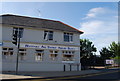
9
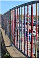
Yarn bombing by Gorrell Tank Car Park
Image: © Oast House Archive
Taken: 24 Sep 2017
0.03 miles
10
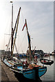
Thames Sailing Barge "Greta", Whitstable, Kent
Image: © Christine Matthews
Taken: 3 Oct 2015
0.03 miles