IMAGES TAKEN NEAR TO
Shottenden Lane, CANTERBURY, CT4 8EZ
Introduction
This page details the photographs taken nearby to Shottenden Lane, CT4 8EZ by members of the Geograph project.
The Geograph project started in 2005 with the aim of publishing, organising and preserving representative images for every square kilometre of Great Britain, Ireland and the Isle of Man.

There are currently over 7.5m images from over14,400 individuals and you can help contribute to the project by visiting https://www.geograph.org.uk
Image Map
Images are licensed for reuse under creativecommons.org/licenses/by-sa/2.0
Notes
- Clicking on the map will re-center to the selected point.
- The higher the marker number, the further away the image location is from the centre of the postcode.
Image Listing (34 Images Found)
Images are licensed for reuse under creativecommons.org/licenses/by-sa/2.0
Image
Details
Distance
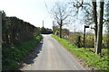
5
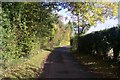
Shottenden Lane
This lane leads from the A252 Canterbury Road to Shottenden Road.
Image: © David Anstiss
Taken: 25 Oct 2009
0.07 miles
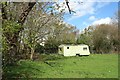
7
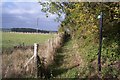
Footpath on Shottenden Lane
This path leads along a fenced path, then through a field, and then over several stiles in a horses paddock towards Shottenden Road.
Image: © David Anstiss
Taken: 25 Oct 2009
0.08 miles
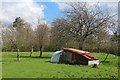
8
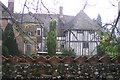
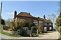
Great Bower
Large historic house, with mishmash of styles of extensions.
Image: © David Anstiss
Taken: 25 Oct 2009
0.09 miles
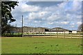
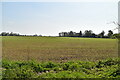
9
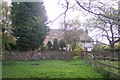
Great Bower (2)
Has an access road from Shottenden Lane.
Image: © David Anstiss
Taken: 25 Oct 2009
0.09 miles