IMAGES TAKEN NEAR TO
Selling Road, CANTERBURY, CT4 8BD
Introduction
This page details the photographs taken nearby to Selling Road, CT4 8BD by members of the Geograph project.
The Geograph project started in 2005 with the aim of publishing, organising and preserving representative images for every square kilometre of Great Britain, Ireland and the Isle of Man.

There are currently over 7.5m images from over14,400 individuals and you can help contribute to the project by visiting https://www.geograph.org.uk
Image Map
Images are licensed for reuse under creativecommons.org/licenses/by-sa/2.0
Notes
- Clicking on the map will re-center to the selected point.
- The higher the marker number, the further away the image location is from the centre of the postcode.
Image Listing (5 Images Found)
Images are licensed for reuse under creativecommons.org/licenses/by-sa/2.0
Image
Details
Distance
2
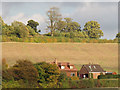
Lane House
An isolated property on New Forest Lane, seen from across the shallow valley.
Image: © Stephen Craven
Taken: 29 Oct 2011
0.21 miles
3
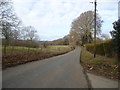
Lower Ensden Road
Towards Lower Ensden and Canterbury Road.
Image: © Robin Webster
Taken: 8 Feb 2018
0.22 miles
4
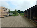
Upper Ensign - Orchard Farmyard on Public Footpath
Image: © James Emmans
Taken: 5 Jun 2016
0.23 miles