IMAGES TAKEN NEAR TO
Ashford Road, CANTERBURY, CT4 7SE
Introduction
This page details the photographs taken nearby to Ashford Road, CT4 7SE by members of the Geograph project.
The Geograph project started in 2005 with the aim of publishing, organising and preserving representative images for every square kilometre of Great Britain, Ireland and the Isle of Man.

There are currently over 7.5m images from over14,400 individuals and you can help contribute to the project by visiting https://www.geograph.org.uk
Image Map
Images are licensed for reuse under creativecommons.org/licenses/by-sa/2.0
Notes
- Clicking on the map will re-center to the selected point.
- The higher the marker number, the further away the image location is from the centre of the postcode.
Image Listing (27 Images Found)
Images are licensed for reuse under creativecommons.org/licenses/by-sa/2.0
Image
Details
Distance
3
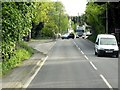
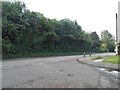
Canterbury Road, near Shalmsford Street
Image: © Stacey Harris
Taken: 28 Dec 2010
0.05 miles
5
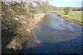
The Great Stour at Shalmsford Bridge
Image: © Julian P Guffogg
Taken: 25 Feb 2012
0.06 miles
6
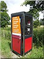
Another sign o' the times
The most frequent users of the phone box in 2007 are Poles and Czechs?
Image: © Jonathan Billinger
Taken: 27 Jun 2007
0.06 miles
7
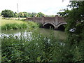
Shalmsford Bridge
The Great Stour is well up after recent heavy rains.
Image: © Jonathan Billinger
Taken: 27 Jun 2007
0.07 miles
8
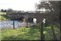
Shalmsford Bridge
Over the Great Stour
Image: © Julian P Guffogg
Taken: 25 Feb 2012
0.07 miles
9
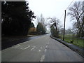
Canterbury Road at the junction of Shalmsford Street
Image: © David Howard
Taken: 12 Jun 2016
0.07 miles
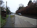
10
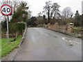
Road over Shalmsford Bridge heading to its junction with the A28
Looking westward,
Image: © Peter Wood
Taken: 18 Feb 2016
0.07 miles