IMAGES TAKEN NEAR TO
Shalmsford Street, CANTERBURY, CT4 7RW
Introduction
This page details the photographs taken nearby to Shalmsford Street, CT4 7RW by members of the Geograph project.
The Geograph project started in 2005 with the aim of publishing, organising and preserving representative images for every square kilometre of Great Britain, Ireland and the Isle of Man.

There are currently over 7.5m images from over14,400 individuals and you can help contribute to the project by visiting https://www.geograph.org.uk
Image Map
Images are licensed for reuse under creativecommons.org/licenses/by-sa/2.0
Notes
- Clicking on the map will re-center to the selected point.
- The higher the marker number, the further away the image location is from the centre of the postcode.
Image Listing (52 Images Found)
Images are licensed for reuse under creativecommons.org/licenses/by-sa/2.0
Image
Details
Distance
1
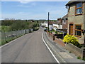
Looking W along Shalmsford Street
Both the settlement and the road are called Shalmsford Street
Image: © Nick Smith
Taken: 26 Apr 2008
0.02 miles
2
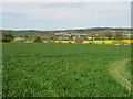
Looking N across the fields to Shalmsford Street
This is the W end of Shalmsford Street, the majority of the housing is out of frame to the right of the photo.
Image: © Nick Smith
Taken: 26 Apr 2008
0.03 miles
3
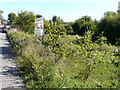
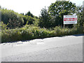
The Old Ballast Pit, Shalmsford Street
The pit of approximately 5.25 acres (2.1 hectares) is for sale.
This is a view of the advertisement board for Image, from the other side of the road.
Image: © John Baker
Taken: 15 Sep 2019
0.03 miles
4
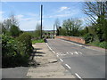
Bridge over the railway on Shalmsford Street
Image: © Nick Smith
Taken: 26 Apr 2008
0.04 miles
5
The Old Ballast Pit, Shalmsford Street
The pit of approximately 5.25 acres (2.1 hectares) is for sale.
This is a sideways view of the advertisement board for Image
Image: © John Baker
Taken: 15 Sep 2019
0.05 miles
6
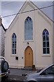
Converted chapel on Shalmsford Street
This chapel has been converted into two homes Old Chapel 1 (on left) and Old Chapel 2 (on the right).
Image: © David Anstiss
Taken: 13 Sep 2009
0.05 miles
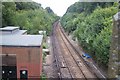
7
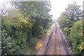
Railway to Chilham
This line leads from Canterbury and Chartham towards Chilham and then on to Ashford International. It is seen from Shalmsford Street roadbridge.
Image: © David Anstiss
Taken: 13 Sep 2009
0.06 miles
9
Railway to Canterbury West
This line leads to Canterbury from Ashford International and Chilham. It passes under Shalmsford Street road bridge.
Image: © David Anstiss
Taken: 13 Sep 2009
0.09 miles
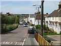
10
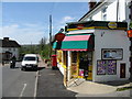
Post office and general store at Shalmsford Street
Image: © Nick Smith
Taken: 26 Apr 2008
0.10 miles