IMAGES TAKEN NEAR TO
Shalmsford Street, CANTERBURY, CT4 7RA
Introduction
This page details the photographs taken nearby to Shalmsford Street, CT4 7RA by members of the Geograph project.
The Geograph project started in 2005 with the aim of publishing, organising and preserving representative images for every square kilometre of Great Britain, Ireland and the Isle of Man.

There are currently over 7.5m images from over14,400 individuals and you can help contribute to the project by visiting https://www.geograph.org.uk
Image Map (Loading...)


Getting Data...Please wait
Leaflet Map data © OpenStreetMap
Images are licensed for reuse under creativecommons.org/licenses/by-sa/2.0
Notes
- Clicking on the map will re-center to the selected point.
- The higher the marker number, the further away the image location is from the centre of the postcode.
Image Listing (52 Images Found)
Images are licensed for reuse under creativecommons.org/licenses/by-sa/2.0
Image
Details
Distance
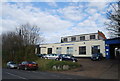
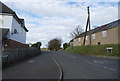
2
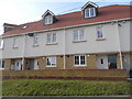
New houses on Shalmsford Street
These were completed around late 2014
Image: © David Howard
Taken: 12 Jun 2016
0.02 miles
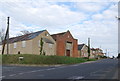
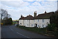
5
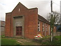
Salvation Army Building
On Shalmsford Street.
Image: © David Anstiss
Taken: 11 Apr 2010
0.04 miles