IMAGES TAKEN NEAR TO
Ashford Road, CANTERBURY, CT4 7PP
Introduction
This page details the photographs taken nearby to Ashford Road, CT4 7PP by members of the Geograph project.
The Geograph project started in 2005 with the aim of publishing, organising and preserving representative images for every square kilometre of Great Britain, Ireland and the Isle of Man.

There are currently over 7.5m images from over14,400 individuals and you can help contribute to the project by visiting https://www.geograph.org.uk
Image Map
Images are licensed for reuse under creativecommons.org/licenses/by-sa/2.0
Notes
- Clicking on the map will re-center to the selected point.
- The higher the marker number, the further away the image location is from the centre of the postcode.
Image Listing (72 Images Found)
Images are licensed for reuse under creativecommons.org/licenses/by-sa/2.0
Image
Details
Distance
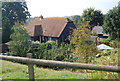
2
Milton Manor Farm
Farm near the A28 Ashford Road.
Image: © David Anstiss
Taken: 11 Apr 2010
0.02 miles
4
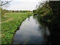
Looking NE along the Great Stour
Taken from a footbridge across the Great Stour.
Image: © Nick Smith
Taken: 26 Apr 2008
0.06 miles
5
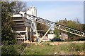
Gravel extraction plant near Chartham
This is one of several gravel extraction facilities along the south bank of the Great Stour. At first sight it looked as though it was still in operation, but closer inspection suggested that it was not.
Image: © David Kemp
Taken: 23 Apr 2009
0.07 miles
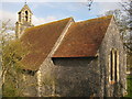
6
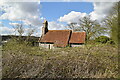
Chapel of St John the Baptist
Grade II* listed.
Image: © N Chadwick
Taken: 7 Apr 2022
0.07 miles
7
Chapel of st John the Baptist
Grade II* listed.
Image: © N Chadwick
Taken: 7 Apr 2022
0.07 miles
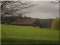
8
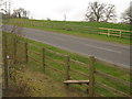
Footpath crosses Cockering Road near Milton Manor Farm
A footpath from Strangers Lane, Thanington leads over the road towards Horton and then towards Chartham. Cockering Road heads left towards Chartham Downs from the A28 Ashford Road.
Image: © David Anstiss
Taken: 11 Apr 2010
0.08 miles
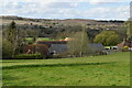
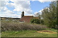
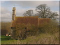
9
Church of St. John (2)
Closed Church near Brett Gravel Works near Milton Manor.
The church closed in 1980 (when there were only six residents in the parish).
Church now part of the Gravel Works.
Image: © David Anstiss
Taken: 11 Apr 2010
0.08 miles
10
Church of St. John
Closed Church near Brett Gravel Works near Milton Manor (in the background).
The church closed in 1980 (when there were only six residents in the parish).
Church now part of the Gravel Works.
Image: © David Anstiss
Taken: 11 Apr 2010
0.09 miles