IMAGES TAKEN NEAR TO
Bigbury Road, CANTERBURY, CT4 7NG
Introduction
This page details the photographs taken nearby to Bigbury Road, CT4 7NG by members of the Geograph project.
The Geograph project started in 2005 with the aim of publishing, organising and preserving representative images for every square kilometre of Great Britain, Ireland and the Isle of Man.

There are currently over 7.5m images from over14,400 individuals and you can help contribute to the project by visiting https://www.geograph.org.uk
Image Map (Loading...)


Getting Data...Please wait
Leaflet Map data © OpenStreetMap
Images are licensed for reuse under creativecommons.org/licenses/by-sa/2.0
Notes
- Clicking on the map will re-center to the selected point.
- The higher the marker number, the further away the image location is from the centre of the postcode.
Image Listing (30 Images Found)
Images are licensed for reuse under creativecommons.org/licenses/by-sa/2.0
Image
Details
Distance
1
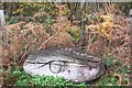
Snake's Head
This head looks like an old part of the Snake's head seat in No Man's Orchard. See Image
Image: © David Anstiss
Taken: 15 Nov 2009
0.10 miles
2
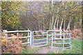
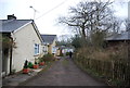
Kissing Gate into Howfield Wood
The North Downs Way leaves No Man's Orchard, to head towards Harbledown from Chatham Hatch.
Image: © David Anstiss
Taken: 15 Nov 2009
0.10 miles
3
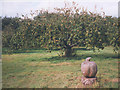
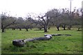
No Man's Orchard
This intriguingly named apple orchard on the North Downs Way celebrates its 60th anniversary in 2008. It was acquired in the 1990s by Chartham and Harbledown Parish Council. More detail at
http://www.england-in-particular.info/orchards/o-kent-i.html
This is a view from ten years earlier, showing one of the wooden sculptures that are a feature of the site.
Image: © Stephen Craven
Taken: Unknown
0.11 miles
5
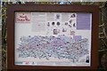
North Downs Way Information Board
In No Man's Orchard in between Chatham Hatch and Harbledown. Shows the route of the Way and notes on the way.
Image: © David Anstiss
Taken: 15 Nov 2009
0.14 miles
6
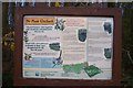
No Man's Orchard Information Board (2)
On the North Downs Way in between Chatham Hatch and Harbledown. This is the first community led orchard in the country. The name "No Man's Orchard" traditionally means that the land straddled two areas of ownership and therefore was not owned by one man. This orchard is one of the few surviving orchards in the area and is protected under the Countryside Stewardship Scheme. The management of the site is co-ordinated by the Kentish Stour Countryside Project. This board explains about the orchard to North Downs Way Walkers.
Image: © David Anstiss
Taken: 15 Nov 2009
0.14 miles
7
North Downs Way in No Man's Orchard
The path heads towards Harbledown through an ancient orchard. This is the first community led orchard in the country. The name "No Man's Orchard" traditionally means that the land straddled two areas of ownership and therefore was not owned by one man. This orchard is one of the few surviving orchards in the area and is protected under the Countryside Stewardship Scheme. The management of the site is co-ordinated by the Kentish Stour Countryside Project. Howfield Wood is in the background
Image: © David Anstiss
Taken: 15 Nov 2009
0.14 miles
8
Snake in No Man's Orchard
This is the first community led orchard in the country. The name "No Man's Orchard" traditionally means that the land straddled two areas of ownership and therefore was not owned by one man. This orchard is one of the few surviving orchards in the area and is protected under the Countryside Stewardship Scheme. The management of the site is co-ordinated by the Kentish Stour Countryside Project. See http://www.kentishstour.org.uk/no%20man's%2060.htm for more details. The snake seat was designed in 1996 by Julie Mecoli and Henry Sparks (students of the Kent Institute of Arts).
Image: © David Anstiss
Taken: 15 Nov 2009
0.15 miles
9
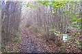
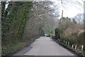
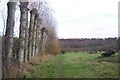
North Downs Way in Howfield Wood
The path heads towards Harbledown from Chartham Hatch.
Image: © David Anstiss
Taken: 15 Nov 2009
0.15 miles