IMAGES TAKEN NEAR TO
New Town Street, CANTERBURY, CT4 7LT
Introduction
This page details the photographs taken nearby to New Town Street, CT4 7LT by members of the Geograph project.
The Geograph project started in 2005 with the aim of publishing, organising and preserving representative images for every square kilometre of Great Britain, Ireland and the Isle of Man.

There are currently over 7.5m images from over14,400 individuals and you can help contribute to the project by visiting https://www.geograph.org.uk
Image Map (Loading...)


Getting Data...Please wait
Leaflet Map data © OpenStreetMap
Images are licensed for reuse under creativecommons.org/licenses/by-sa/2.0
Notes
- Clicking on the map will re-center to the selected point.
- The higher the marker number, the further away the image location is from the centre of the postcode.
Image Listing (37 Images Found)
Images are licensed for reuse under creativecommons.org/licenses/by-sa/2.0
Image
Details
Distance
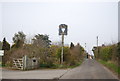
4
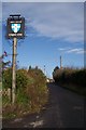
Chapter Arms Pub Sign
On New Town Street.
Image: © David Anstiss
Taken: 15 Nov 2009
0.05 miles
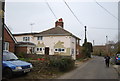
9
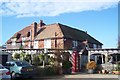
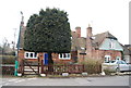
The Chapter Arms Public House, Chartham Hatch
On New Town Street.
Image: © David Anstiss
Taken: 15 Nov 2009
0.08 miles
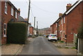
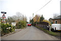
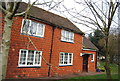
10
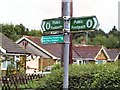
Chartham Hatch
Houses on Bigbury Road where the North Downs Way footpath crosses it at Chartham Hatch.
Image: © Roger May
Taken: 12 Sep 2005
0.08 miles