IMAGES TAKEN NEAR TO
Pilgrims Way, CANTERBURY, CT4 7LR
Introduction
This page details the photographs taken nearby to Pilgrims Way, CT4 7LR by members of the Geograph project.
The Geograph project started in 2005 with the aim of publishing, organising and preserving representative images for every square kilometre of Great Britain, Ireland and the Isle of Man.

There are currently over 7.5m images from over14,400 individuals and you can help contribute to the project by visiting https://www.geograph.org.uk
Image Map
Images are licensed for reuse under creativecommons.org/licenses/by-sa/2.0
Notes
- Clicking on the map will re-center to the selected point.
- The higher the marker number, the further away the image location is from the centre of the postcode.
Image Listing (38 Images Found)
Images are licensed for reuse under creativecommons.org/licenses/by-sa/2.0
Image
Details
Distance
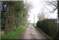
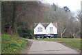
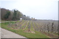
3
Peek-a-boo
Unnamed house on track through Nickle Farm orchards. The splendidly named Fright Wood is on the immediate left whilst the orchards line the slope of the down as it drops towards the railway line
Image: © Simon Carey
Taken: 24 Aug 2007
0.04 miles
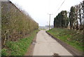
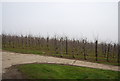
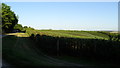
8
Apple Orchards at Nickle Farm
Many hectares of orchards grown at this farm.
Image: © Oast House Archive
Taken: 22 Sep 2009
0.08 miles
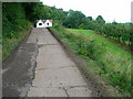
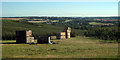
10
Apple orchard above Dunning Shaw, Stour Valley, Kent
Image: © Colin Park
Taken: 21 Sep 2019
0.09 miles