IMAGES TAKEN NEAR TO
The Hyde, Bolts Hill, CANTERBURY, CT4 7LE
Introduction
This page details the photographs taken nearby to The Hyde, Bolts Hill, CT4 7LE by members of the Geograph project.
The Geograph project started in 2005 with the aim of publishing, organising and preserving representative images for every square kilometre of Great Britain, Ireland and the Isle of Man.

There are currently over 7.5m images from over14,400 individuals and you can help contribute to the project by visiting https://www.geograph.org.uk
Image Map (Loading...)


Getting Data...Please wait
Leaflet Map data © OpenStreetMap
Images are licensed for reuse under creativecommons.org/licenses/by-sa/2.0
Notes
- Clicking on the map will re-center to the selected point.
- The higher the marker number, the further away the image location is from the centre of the postcode.
Image Listing (57 Images Found)
Images are licensed for reuse under creativecommons.org/licenses/by-sa/2.0
Image
Details
Distance
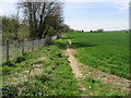
1
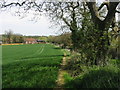
Looking NE along footpath
This is part of the Stour Valley Walk, to the right of the path is the railway, which is crossed just before the buildings.
Image: © Nick Smith
Taken: 26 Apr 2008
0.04 miles
9
Route of the Stour Valley Walk alongside the railway line
Image: © Nick Smith
Taken: 26 Apr 2008
0.07 miles
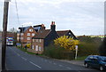
10
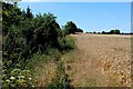
Stour Valley Walk at Shalmsford Street
The long distance footpath follows the Canterbury West/Ashford Railway line at this point - somewhat overgrown, and subject to nettle infestation.
Image: © Chris Heaton
Taken: 9 Aug 2015
0.07 miles