IMAGES TAKEN NEAR TO
The Green, CANTERBURY, CT4 7JW
Introduction
This page details the photographs taken nearby to The Green, CT4 7JW by members of the Geograph project.
The Geograph project started in 2005 with the aim of publishing, organising and preserving representative images for every square kilometre of Great Britain, Ireland and the Isle of Man.

There are currently over 7.5m images from over14,400 individuals and you can help contribute to the project by visiting https://www.geograph.org.uk
Image Map
Images are licensed for reuse under creativecommons.org/licenses/by-sa/2.0
Notes
- Clicking on the map will re-center to the selected point.
- The higher the marker number, the further away the image location is from the centre of the postcode.
Image Listing (217 Images Found)
Images are licensed for reuse under creativecommons.org/licenses/by-sa/2.0
Image
Details
Distance
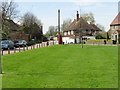
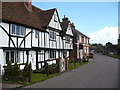
3
Houses on the Village Green, Chartham
Pleasant dwellings tidily arranged along the northern fringe of the village green, Chartham.
Image: © Chris Heaton
Taken: 9 Aug 2015
0.01 miles
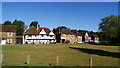
6
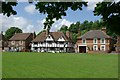
Village Green, Chartham.
View of houses bounding the North side of the village green.
Image: © john salter
Taken: 31 May 2007
0.03 miles
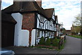
7
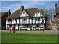
Bedford House, former poor house, built in 1420
Image: © Nick Smith
Taken: 26 Apr 2008
0.03 miles
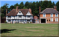
9
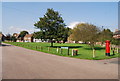
The Green, Chartham
Village green in Chartham.
Image: © N Chadwick
Taken: 27 Sep 2008
0.04 miles