IMAGES TAKEN NEAR TO
Parish Road, CANTERBURY, CT4 7JU
Introduction
This page details the photographs taken nearby to Parish Road, CT4 7JU by members of the Geograph project.
The Geograph project started in 2005 with the aim of publishing, organising and preserving representative images for every square kilometre of Great Britain, Ireland and the Isle of Man.

There are currently over 7.5m images from over14,400 individuals and you can help contribute to the project by visiting https://www.geograph.org.uk
Image Map
Images are licensed for reuse under creativecommons.org/licenses/by-sa/2.0
Notes
- Clicking on the map will re-center to the selected point.
- The higher the marker number, the further away the image location is from the centre of the postcode.
Image Listing (172 Images Found)
Images are licensed for reuse under creativecommons.org/licenses/by-sa/2.0
Image
Details
Distance
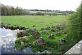
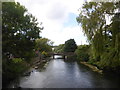
2
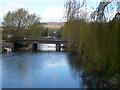
The Great Stour and the railway bridge from the bridge on Parish Road
Image: © pam fray
Taken: 12 Apr 2008
0.04 miles
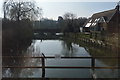
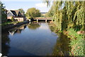
3
Crossing the Great Stour
Looking upstream towards the railway bridge that carries the Ashford line over the river.
Image: © Simon Carey
Taken: 24 Aug 2007
0.04 miles
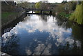
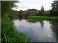
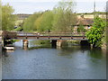
5
The Great Stour, Chartham
Viewed from the road bridge looking towards the railway bridge.
Image: © pam fray
Taken: 20 Aug 2016
0.04 miles
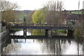
6
Railway line crossing the Great Stour
This is the London-Canterbury West-Ramsgate line.
Image: © Nick Smith
Taken: 26 Apr 2008
0.04 miles