IMAGES TAKEN NEAR TO
Crundale, CANTERBURY, CT4 7EW
Introduction
This page details the photographs taken nearby to CT4 7EW by members of the Geograph project.
The Geograph project started in 2005 with the aim of publishing, organising and preserving representative images for every square kilometre of Great Britain, Ireland and the Isle of Man.

There are currently over 7.5m images from over14,400 individuals and you can help contribute to the project by visiting https://www.geograph.org.uk
Image Map
Images are licensed for reuse under creativecommons.org/licenses/by-sa/2.0
Notes
- Clicking on the map will re-center to the selected point.
- The higher the marker number, the further away the image location is from the centre of the postcode.
Image Listing (17 Images Found)
Images are licensed for reuse under creativecommons.org/licenses/by-sa/2.0
Image
Details
Distance
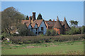
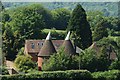
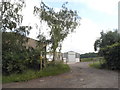
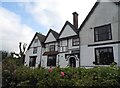
6
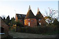
Winchcombe Oast Cottage, Crundale, Kent
Image: © Oast House Archive
Taken: 10 Dec 2008
0.03 miles
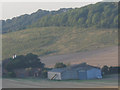
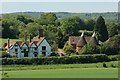
8
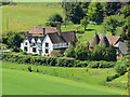
Winchcombe Farm
Seen from the path that leads through the triple SI to the National Nature Reserve.
Image: © David M Clark
Taken: 18 May 2020
0.03 miles