IMAGES TAKEN NEAR TO
Sole Street, CANTERBURY, CT4 7ER
Introduction
This page details the photographs taken nearby to Sole Street, CT4 7ER by members of the Geograph project.
The Geograph project started in 2005 with the aim of publishing, organising and preserving representative images for every square kilometre of Great Britain, Ireland and the Isle of Man.

There are currently over 7.5m images from over14,400 individuals and you can help contribute to the project by visiting https://www.geograph.org.uk
Image Map
Images are licensed for reuse under creativecommons.org/licenses/by-sa/2.0
Notes
- Clicking on the map will re-center to the selected point.
- The higher the marker number, the further away the image location is from the centre of the postcode.
Image Listing (34 Images Found)
Images are licensed for reuse under creativecommons.org/licenses/by-sa/2.0
Image
Details
Distance
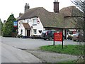
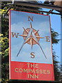
2
The Compasses Inn, Pub Sign, Sole Street
On Image
Image: © David Anstiss
Taken: 10 Oct 2010
0.04 miles
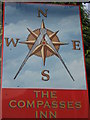
3
Compasses Inn
Sign for Image, a Shepherd Neame pub at Sole Street.
Image: © Oast House Archive
Taken: 19 May 2020
0.05 miles
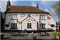
6
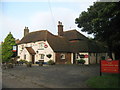
The Compasses Inn, Sole Street
Village Public house with Image
Image: © David Anstiss
Taken: 10 Oct 2010
0.05 miles

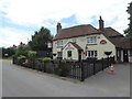
8

The Compasses Inn, Sole Street
A Shepherd Neame pub on Sole Street.
Also see Image
Image: © Oast House Archive
Taken: 8 Apr 2011
0.06 miles
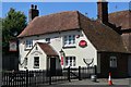
9
The Compasses Inn, Sole Street
A Shepherd Neame public house that has circa 1480 painted across the front porch.
Image: © pam fray
Taken: 6 Jul 2020
0.06 miles
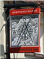
10
Compasses Inn
A Shepherd Neame pub at Sole Street.
Image: © Oast House Archive
Taken: 19 May 2020
0.06 miles