IMAGES TAKEN NEAR TO
Ashford Road, CANTERBURY, CT4 7DG
Introduction
This page details the photographs taken nearby to Ashford Road, CT4 7DG by members of the Geograph project.
The Geograph project started in 2005 with the aim of publishing, organising and preserving representative images for every square kilometre of Great Britain, Ireland and the Isle of Man.

There are currently over 7.5m images from over14,400 individuals and you can help contribute to the project by visiting https://www.geograph.org.uk
Image Map
Images are licensed for reuse under creativecommons.org/licenses/by-sa/2.0
Notes
- Clicking on the map will re-center to the selected point.
- The higher the marker number, the further away the image location is from the centre of the postcode.
Image Listing (19 Images Found)
Images are licensed for reuse under creativecommons.org/licenses/by-sa/2.0
Image
Details
Distance
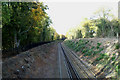
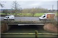
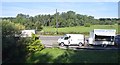
4
Footbridge over the railway, near Chilmans Down
This bridge is on the path leading to the A28 Ashford Road, from the Stour Valley Walk (long distance path).
Image: © David Anstiss
Taken: 13 Sep 2009
0.17 miles
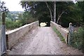
6
Farmer's bridge over the Canterbury-Ashford line
Image: © David Long
Taken: 27 Oct 2009
0.18 miles
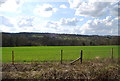
7
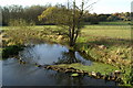
Looking across to Chilham Castle from the A28
A decomposing sheep lies in the Great Stour in the bottom right-hand corner....
Image: © David Long
Taken: 27 Oct 2009
0.18 miles
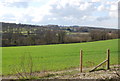
10
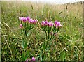
Common centaury, on the downs near Chilham
Centaurium erythraea, growing by the Stour Valley Walk.
Image: © pam fray
Taken: 3 Jul 2023
0.20 miles