IMAGES TAKEN NEAR TO
Nackington Road, CANTERBURY, CT4 7AT
Introduction
This page details the photographs taken nearby to Nackington Road, CT4 7AT by members of the Geograph project.
The Geograph project started in 2005 with the aim of publishing, organising and preserving representative images for every square kilometre of Great Britain, Ireland and the Isle of Man.

There are currently over 7.5m images from over14,400 individuals and you can help contribute to the project by visiting https://www.geograph.org.uk
Image Map
Images are licensed for reuse under creativecommons.org/licenses/by-sa/2.0
Notes
- Clicking on the map will re-center to the selected point.
- The higher the marker number, the further away the image location is from the centre of the postcode.
Image Listing (9 Images Found)
Images are licensed for reuse under creativecommons.org/licenses/by-sa/2.0
Image
Details
Distance
1

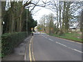
Roadworks on Nackington Road, Canterbury
The sign on the left refers to the Chaucer Hospital, and Underwood Close is a short distance ahead.
Image: © Bill Boaden
Taken: 24 Jun 2012
0.07 miles
2
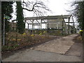
Derelict barn on footpath from Nackington Road
Image: © Nick Smith
Taken: 18 Feb 2010
0.08 miles
3
Looking W along Langton Lane
The lane leads to The Simon Langton Grammar School for boys.
Image: © Nick Smith
Taken: 18 Feb 2010
0.09 miles
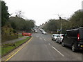
4
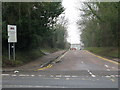
Road Signage on Nackington Road
Nackington Road leads into Canterbury. It then passes Simon Langton School for Boys, hence the warning signs.
Image: © David Anstiss
Taken: 26 Mar 2010
0.15 miles
5
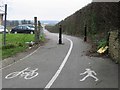
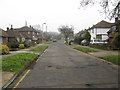
Footpath and cycle track into Canterbury from the Simon Langton boys school
Image: © Nick Smith
Taken: 18 Feb 2007
0.17 miles
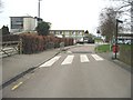
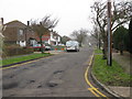
7
Junction of The Foreland with Nackington Road
Image: © Nick Smith
Taken: 18 Feb 2010
0.22 miles