IMAGES TAKEN NEAR TO
Faussett Hill, CANTERBURY, CT4 7AL
Introduction
This page details the photographs taken nearby to Faussett Hill, CT4 7AL by members of the Geograph project.
The Geograph project started in 2005 with the aim of publishing, organising and preserving representative images for every square kilometre of Great Britain, Ireland and the Isle of Man.

There are currently over 7.5m images from over14,400 individuals and you can help contribute to the project by visiting https://www.geograph.org.uk
Image Map
Images are licensed for reuse under creativecommons.org/licenses/by-sa/2.0
Notes
- Clicking on the map will re-center to the selected point.
- The higher the marker number, the further away the image location is from the centre of the postcode.
Image Listing (41 Images Found)
Images are licensed for reuse under creativecommons.org/licenses/by-sa/2.0
Image
Details
Distance
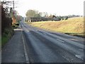
3
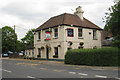
B2068 towards Canterbury
Through Street End, Lower Hardres, with the Granville pub on the right.
Image: © Robin Webster
Taken: 8 Jul 2018
0.07 miles
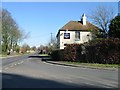
5
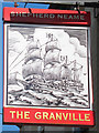
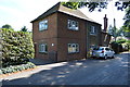
The Granville, Street End
A Shepherd Neame pub.
Image: © Oast House Archive
Taken: 24 Jun 2010
0.08 miles
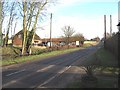
10
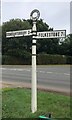
Old Direction Sign - Signpost by the B6028, Faussett Hill, Lower Hardres Parish
Annulus finial - 3 arms, 1 broken off; Kent CC parish halo by the B2068, in parish of Lower Hardres (Canterbury District), junction of Faussett Hill with Hardres Court Road.
To be surveyed
Milestone Society National ID: KE_TR1453
Image: © Milestone Society
Taken: Unknown
0.10 miles